SlideShare a Scribd company logo
Unmanned Aerial Remote Sensing
Services (UAV)
Geo Sense Sdn. Bhd.
79A, Jalan Seri Impian 1
Taman Impian Emas
81300, Johor Bahru, Johor, Malaysia
0197266411 www.geosense.com.my


                                      www.geosense.com.my
Agenda, catching 15 min.
•   What inspire us / idea background / needs
•   UAV tech. developments
•   Sharing experience
•   Potential applications
•   Moving forward
•   Looking forward
Google Earth Launch 2005, earth visualization, layers of sat.
imagery,awesome, geo peeping, mapping, location awareness,
neogeography
visualization, geo tagging, sharing,
participationary, wikimapia, API, web services
Web 2.0
Where 2.0
Geo - Web
Challenge to GIS, Government, territorial needs GIS,
visualization, GE awareness among decision makers
sharing, collaboration, WGIS transparency, GODCHA


     GIS
                                           IT / WWW
The important of visualization, aerial imagery
Using Aerial photo for effective visualization, Planning
Understanding, transparency, pic. tells thousand stories..
Sources of Aerial Imagery
                                                                    Perolehan imej satellite adalah terhad, walaupun ada di
                                                                    Google, tetapi imej-imej tersebut adalah ber-resolusi
                                   Light Aircraft                   rendah serta tidak terkini. Untuk mendapatkan imej ber-
        Imaging                    ketinggian 10k – 30k kaki        resolusi tinggi, pesawat ringan dan helikopter
        Satellite                                                   digunakan, namum kos agak tinggi dan kurang
                                                                    ekonomik untuk liputan yang kecil,
        500-800 km          Cost
                                                                                         RC AIrcarft / UAV
                                                                                         Ketinggian 500 – 5000 kaki

                                            • Aerial Camera System
                                            • Radiometric resolution
                                            • 3 in – 60 in resolution
                                              (avg 30 in resolution)
   Cloud Issues                             • Aerial mapping survey
                                            • IPSAR (SAR) / LIDAR                       • Natural color (RGB)
                                                                                        • 7 - 15 cm resolution
                                                                                        • Surveillance / Monitoring


                                                                            200 meter
90 km                              3 km


                                                                                                300 meter
                    30 km                           3 km
Limitation of Satellite Images


                            Tangkak


  Muar                                Kota Tinggi


             Batu Pahat
Limitation of Satellite Images
Cloud cover
Limited resolution (60 – 200 cm)
Out dated (Google average 2-3 years / Aerial photo - 1 – 4 mth)


    Danga Bay


                                                             Geo Sense Sdn. Bhd.
References to Google Earth
-Outdated
Part of Study Areas (Future Development &
        Monitoring)


Imej lama 2 tahun atau lebih
Kejelasan melebihi 2 meter resolusi per pixel
Liputan awan 60%
Light Aircraft with sosphicated aerial camera system taking
aerial images for remote sensing and mapping


          Contoh Imej Pesawat Ringan
          - Terbang lebih tinggi – kawasan liputan lebih meluas
          - Tambah Nilai – Muatan - Multi spectrum camera, LIDAR, 3D Camera etc
          - Tertakluk kebenaran penerbangan (DCA)
          - Kepakaran yang kurang - kos perolehan dan pengendalian yang tinggi.
                                                                         Geo Sense Sdn. Bhd.
Hobbyists, RC, aerial photography, limited
endurance, height, camera angles & non precision
personal use
Military to Civilian

      Potential of UAV
Civilian UAV Development
Wikipedia..An unmanned aerial
                 vehicle (UAV; also known as a
                 remotely piloted vehicle or RPV,
                 or Unmanned Aircraft System
                 (UAS)) is an aircraft that flies
                 without a human crew on board the
                 aircraft. Their largest uses are in
                 military applications. To distinguish
                 UAVs from missiles, a UAV is
                 defined as a reusable, uncrewed
                 vehicle capable of controlled from
                 thousand miles away
HALE, MALE UAV


                  Mini UAV
UAV, More than 1 mil. flight hours in Afghanistan and Iraq (2009)
Future of war is unmanned / robotic
ORBITAL low earth orbit (Mach 25+)
                                              HALE (high altitude, long endurance)
                                              over 30,000 ft and indefinite range
                                                                                          Type of UAV
                                                               MALE (medium altitude, long
                                                               endurance) up to 30,000 ft
                                                               (9,000 m) and range over 200 km


NATO type 10,000 ft (3,000 m) altitude,
up to 50 km range
                                                                      Tactical 18,000 ft (5,500 m)
                                                                      altitude, about 160 km range

                                             HYPERSONIC high-speed,
                                             supersonic (Mach 1-5) or
                                             hypersonic (Mach 5+)
                                             50,000 ft (15,200 m) or
                                             suborbital altitude, range
                                             over 200km
                                                                                Handheld 2,000 ft (600 m) altitude,
                                                                                about 2 km range
                                                                                Close 5,000 ft (1,500 m) altitude, up to
                                                                                10 km range
Overview - Unmanned Aerial Vehicle –
From Military to Civilian applications                                   Aludra Mal’s UAV


    Sample of Civilian Application (please google)
China – Event Monitoring Olympic   Canada – Agri, Forestry &GIS
Games)

                                                                                                   UK – Police
                                                                                                   Monitoring


 Holland Traffic Control &         Earthquake – search and rescue   Japan – Agri, Spray Fertilizer & insect control
 Urban Monitoring
Everybody can UAV
      About autonomous chipset & the right airframe
      Autopilot from USD$100 to USD100,000


Chris Anderson
Chief Editor Wired Magazine
Founder DIY Drone
Author The Long Tail
                              Open source   Licensing
Civilian UAV People


Dr Stephan J Morris    David Riallant                                     Chris Anderson
                                                     Li Jing, Prof.
MLB UAV                Pict’ Earth                                        Chief Editor Wired Magazine
                                                     Beijing University
President & Founder    Image Processing Specialist                        Founder DIY Drone
                                                                          Author The Long Tail
Potential civilian UAV Applications
• Property management / Monitoring
   – Feasibility / Planning study
   – Progress monitoring
   – Enforcement
• Agriculture
   – Vegetation monitoring
   – Variable rate application
• Emergency Response / Disaster Management
   – Search and rescue
   – Hot spot identification
• Environmental Monitoring
   – Riparian assessment
   – Hydrocarbon (oil) spills


                                             Geo Sense Sdn. Bhd
Possible Applications
• Utility Monitoring
  – Pipeline and electrical transmission line
    inspection
• Law Enforcement
  – Situation awareness during sensitive
    situations, e.g. hostage takings
  – Grow operations
• Many, many more!


                                                Geo Sense Sdn. Bhd
Geo Sense Mini UAV

Unmanned Remote Sensing
   Sharing experience
What is Air Sense
    (bro. cut d bull, run d video)

•   Aerial photography on
    demand
•   Malaysia comprehensive
    high resolution aerial
    imagery platform
•   Visualization - valuable
    resource & record of how the
    landscape has changed over
    time.
•   Development of 3D Geo
    Spatial Database
•   Complementing
    eGovernment initiative &
    various applications
•   Better decision making – in
    planning, investment,
    enforcement
Why we choose a UAV?
• Fly below cloud, clearer image resolution
• On Demand - Flexible deployment.
• less investment compare with traditional
  aircraft
• Less operating cost vs traditional
• Precision – GPS guided eliminates putting
  people in harms way
• Future Technology – evolving
• Barrier of entry
                                      Geo Sense Sdn. Bhd
Canadian Micropilot,
autopilot chips
producer,
Cropcam, mini glider
based UAV for agri.
(N. America & N.
Europe) Stable sys.


                       Future - Re-engineer & work on
                       Our own platform & autopilot
                       system
Battery operated
Hand launch Mini UAV
Geo Sense “Glider Based UAV”

                                      Battery operated, light, quite (discreet), stable,
                                      low maintenance, limited take off & recovery space.


Geo Sense UAV System
Length: 1.7m Weight: 2 kg            Current productivity:
30 min endurance                     1 mission : 1.5 – 2 sq km
Air speed 61 km / hrs                1 days – 5 sq km (3-4 flights)
Total Distance : 24 km               Customer needs 10 – 20 sq km
Alt. Max 5000 feet
Micropilot Ardupilot / Attopilot /
Live & Recorded Video
Battery operator (silence)
Geo Sense Sdn. Bhd.
Micro hand launch
UAV System
Flight planning system


Ground control system &
telemetry
Mobile & Telemetry
                           On site flight monitoring
                           System & live video


Wireless
Antenna telemetry system


                                         Flight
                                         Live monitoring
UAV system in the box
3 kg system with casing
Ground Control System
2-3 operators
15-20min. Installation & ready to fly
Site Installation
Transferring flight data from ground control system
(flight instruction) to UAV autonomous system
Final test before take off / flight mission.
Geo Sense UAV service
Hand launch glider UAV
UAV on flight mission
After flight mission completed, UAV ready to land on the recovery net
UAV manually landed on net for recovery
Images are downloaded from the camera for stitching process
2 sq km coverage consist of approx. 100 piece of vertical aerial images of
ground size 250 x 270m. Images are stitched/mosaic to show the bigger covering
area.


Yoo..go to zoomifly bro!!
Quality sample of one aerial picture at 100% view (able
to zoom for detail) each image resolution at 7-10 cm at
altitude 1000 ft
Images are stitched (mosaic) using
remote sensing software to produce the
bigger aerial picture.
Pemprosesan Imej
(Orthoractification Process)
- Mosaic / Stitch
- Ground Control Point
- Kemaskini pemetaan


                               Proses lapikan Individual imej (lapping)
Sample of one aerial images that
                                           already been stitched


Current capacity, UAV can cover 1.5-2 sq km area in a single flight
mission. Current R&D We to increase the capacity.
Patching to existing Satellite Image
(Practical & economical)


 Satellite Images                               UAV Images


   Sample area Danga Bay, Johor Bahru
                                        Geo Sense Sdn. Bhd.
Imej UAV


Imej Satellite


                      Pusat Pentadbiran Baru Kerajaan Johor
                      Nusajaya – patch/overlay to satellite
Sample of UAV image overlayed in Google Map
satellite image. For image online sharing and
showcase
UAV image premium
                                                    High resolution images


                                                                    Pic satellite
                                                                    Cloud cover


                 Pic satellite
                 Cloud cover

Sample aerial images (in Tangkak, Johor), overlay
at existing cloud cover satellite image.
Image Comparison (Satellite & Traditional Aerial Photo)
                                      Pada zoom digital ketinggian 1000 kaki


 Satellite Image                   Aircraft                                UAV Images
 Danga Bay Business Complex        Tapak pembinaan di Taman Pulai          Danga Bay Business Complex


Perbezaan Kejelasan
Imej Udara dari 3
sumber utama;
Resolusi imej satellite semasa
adalah sekitar 200 cm per pixel,
Imej pesawat, 50 cm & UAV
dibawah 15 cm per pixel.

Imej UAV boleh diperolehi
dengan cepat dan lebih jelas,
dan perolehan yang cepat iaitu
sesuai untuk pemantauan
makro (macro planning)
                                          Imej UAV – < 15 cm per pixel resolusi
                                          visual yang jelas dan sesuai untuk kegunaan perancangan mikro
Resolution advantage – micro planning etc. (Satellite Imej vs UAV Imej)


Sat Image                                Cherating Club Med
Sebahagian Kampung Pasir, Tampoi, Johor
Imej Satellite pada ketinggian yang sama (1,200 kaki)
Sebahagian Kampung Pasir, Tampoi, Johor
Imej UAV Geo Sense diambil pada Oct. 2009 Ketinggian 1,200 kaki
Geo Sense UAV service
Sebahagian Mesjid Tampoi, Kampung Pasir,
Imej Satellite pada ketinggian yang sama (1,200 kaki)
Danga Bay – March 2009
Danga Bay Commercial Complex– March 2009
Pusat Pentadbiran Kerajaan Johor, Nusajaya – March 2009
UAV Quality Images
                                           Danga Bay


Tebus Guna Tanah, Danga Bay – March 2009
Potential Applications
Updating / Patching Current
Unclear Satellite Imagery
                Geo Sense Sdn. Bhd.
Property Monitoring & Asset Management


                                                      Canopy


                                                 Property under
                                                   renovation

                                         Geo Sense Sdn. Bhd.
Project Progress Monitoring
Enforcement & Auditing
Aerial Survey – Squatter
Management etc


                           Zoom Area
Integration
GIS / Boundaries Info
                                                                                Lot 12333


                Lot 15621
Lot 25621                                                Future
                                                         Development
                                                         Ref Lot 112122


                                  Lot 76575


        Lot 34243

                                                               Mengesan gerai haram –
                 Application                                   Tujuan Penguatkuasaan
                 Development            Future
                 Ref Lot 112122         Development
                                        Ref Lot 112122              Future
                                                                    Development
                                                                    Ref Lot 112122
GIS / Web Integration

 Œ
     


                            N
             “
                            


                                S
                            ‘       


         Ž
                        ’
River Monitoring / Flood Management
Pemantauan Tadahan Air & Sungai
(Environmental protection)


                             Pasir Gudang
Property Monitoring
Agricultural / Crop Monitoring /Precision farming


                                           Infrared Imagery
                                           Crop Analysis
Palm Oil Monitoring
social political
Planning database
Semporna, Sabah, Community, Postal network Study
MCMC
Sample of Multiple Government / Civilian             Supporting GIS System
Applications


                                                                        Tanah Runtuh


   Planning & Monitoring Center


                                                                                 Flood
   Environmental Monitoring
                                                      Catastrophic / Flood etc
                                  Crowd Monitoring
Back to requirement.. Supporting GIS layers
                                                                           Maklumat Asas
                                                                      sempadan/
                                                                      Cadastral

                                                                      Jalan / POI


                                                                      Populasi


                                                                      Imej Satellite


                                                                      Imej UAV

                                       Data Accessibility
  Visualization & Analyzing Platform                        Presentation
Design Opportunity - Mini – hand launch UAV utilization in military
Practical for infantry and surveillance military application
Malaysia Design Community
• Innovation, be different, do something new
• Our experience in Geosense
  – entrepreneurial sprit + engineering
  – UAV a complex sys. multi disciplinary, we
    crash many x, a challenge to keep improve
  – Use other technology :(
  – Re-engineer, continuous improvement-learn,
    collaboration,
  – our own tech. proud :)
• We are at the beginning - Long way to go
Looking for
• New ideas
• Collaboration
• Improvement
  – Endurance
  – Load
  – Sensors
  – Software (autopilot & image processing)
• Customers
Thanks You

ismaili@geosense.com.my
    +6 019 726 6411
  www.geosense.com.my

More Related Content

PDF
AirSense - Neogeography
Ismail Ibrahim
 
PPTX
UTAT UAV PDR 2015.pptx
Wenkai Xu
 
PPT
UAV Presentation
Ruyyan
 
PPTX
Drone-Unmanned Aerial Vehicle
shivu1234
 
PPTX
"Click here" to build your UAV
Dirk Gorissen
 
PPTX
Autonomous Underwater Vehicle (AUVs)
MM.H.Saboo Siddik Polytechnic
 
PDF
Autonomous vtol jun01
Clifford Stone
 
PPTX
Fixed Wing UAV Drones Market Professionally Investigated for Its Competitive ...
Pete Jones
 
AirSense - Neogeography
Ismail Ibrahim
 
UTAT UAV PDR 2015.pptx
Wenkai Xu
 
UAV Presentation
Ruyyan
 
Drone-Unmanned Aerial Vehicle
shivu1234
 
"Click here" to build your UAV
Dirk Gorissen
 
Autonomous Underwater Vehicle (AUVs)
MM.H.Saboo Siddik Polytechnic
 
Autonomous vtol jun01
Clifford Stone
 
Fixed Wing UAV Drones Market Professionally Investigated for Its Competitive ...
Pete Jones
 

Viewers also liked (19)

PDF
Unmanned Aerial Systems
jmanthey
 
PDF
Challenges of UAV platforms
CIMMYT
 
PDF
Design, Fabrication and Modification of Small VTOL UAV
Akshat Srivastava
 
PPTX
DESIGN AND FABRICATION OF QUADCOPTER
Prasanna Achanti
 
PPT
Unicity saurbh building your organization using 2 4-1
saurbh yadav
 
PDF
Design and Development of a Hybrid UAV
Camilo Vergara
 
PPTX
Micro Unmanned Aerial Vehicles Presentation
bm_njoi
 
PPTX
Considerations for choosing a data link for UAV
Yaron Benita
 
PDF
Uav market opportunity
NiMA Asghari
 
PPT
New business opportunity with Unicity International
John Pozun
 
PPTX
Micro air vehicles
Akhilesh Arkala
 
PPT
Dikey iniş ve kalkış yapabilen hava araçları
Mete Cantekin
 
PPT
Havacılıkta kavramsal tasarımlar
Mete Cantekin
 
PPTX
Unicity Sharing The Plan
Matt Imperio
 
PPTX
Nano uav
naveen kumar
 
PPTX
Design and Operation of UAV
Sai Shubhankar
 
PPTX
ICRA 2013 Tilt-TriRotor
Kostas Alexis
 
PPTX
A system of engine
kivancgunendi
 
PPT
Unicity International Presentaion Nov. 26 2013. Include Company Profile, Pro...
Maheep Jyot
 
Unmanned Aerial Systems
jmanthey
 
Challenges of UAV platforms
CIMMYT
 
Design, Fabrication and Modification of Small VTOL UAV
Akshat Srivastava
 
DESIGN AND FABRICATION OF QUADCOPTER
Prasanna Achanti
 
Unicity saurbh building your organization using 2 4-1
saurbh yadav
 
Design and Development of a Hybrid UAV
Camilo Vergara
 
Micro Unmanned Aerial Vehicles Presentation
bm_njoi
 
Considerations for choosing a data link for UAV
Yaron Benita
 
Uav market opportunity
NiMA Asghari
 
New business opportunity with Unicity International
John Pozun
 
Micro air vehicles
Akhilesh Arkala
 
Dikey iniş ve kalkış yapabilen hava araçları
Mete Cantekin
 
Havacılıkta kavramsal tasarımlar
Mete Cantekin
 
Unicity Sharing The Plan
Matt Imperio
 
Nano uav
naveen kumar
 
Design and Operation of UAV
Sai Shubhankar
 
ICRA 2013 Tilt-TriRotor
Kostas Alexis
 
A system of engine
kivancgunendi
 
Unicity International Presentaion Nov. 26 2013. Include Company Profile, Pro...
Maheep Jyot
 
Ad

Similar to Geo Sense UAV service (20)

PDF
1 Aerial View - Drone Snapshot2
Garth Torasadhewa
 
PPT
UAVmapping_11111.ppt
BismaJZ
 
PPTX
Unmanned aerial vehicles
Shahnawaz Alam
 
PPT
Rpv Uav drone
muhammad shoaib
 
PDF
Aerial photography vs RS satellite
Sumant Diwakar
 
PDF
Timmins how would you like to use ua vs
GeCo in the Rockies
 
PPTX
Classes of Unmanned Aerial vehicles and Systems.pptx
INAMULHASAN41
 
PPTX
UNMANNED AERIAL VEHICLE
Thirumal Aero
 
PDF
Geo Sense - UAV service, unmanned remote sensing
Ismail Ibrahim
 
PDF
Helicopter With Gps
esthershiang88
 
PPTX
Geo Sense Unmanned Aerial Mapping Services
Ismail Ibrahim
 
PPTX
Sentinel Air LLC, Capability Brief
SentinelAir
 
PDF
GeoEye-2 Webinar
DigitalGlobe
 
KEY
Tyr3000 presentation
philkloke
 
PDF
Skyeton - Raybird 3
Skyeton
 
PDF
Unmanned Aerial Vehicle Application
NopphawanTamkuan
 
PDF
Local Government Showcase Drones for the planning
ssusera9462d1
 
PPT
2012 ASPRS Track, Satellite Image Geometry, Gene Dial
GIS in the Rockies
 
PDF
Uav image recognition technology and applications
Texas Natural Resources Information System
 
PDF
The use of an unmanned aerial vehicle as a remote sensing platform in agricul...
Angelo State University
 
1 Aerial View - Drone Snapshot2
Garth Torasadhewa
 
UAVmapping_11111.ppt
BismaJZ
 
Unmanned aerial vehicles
Shahnawaz Alam
 
Rpv Uav drone
muhammad shoaib
 
Aerial photography vs RS satellite
Sumant Diwakar
 
Timmins how would you like to use ua vs
GeCo in the Rockies
 
Classes of Unmanned Aerial vehicles and Systems.pptx
INAMULHASAN41
 
UNMANNED AERIAL VEHICLE
Thirumal Aero
 
Geo Sense - UAV service, unmanned remote sensing
Ismail Ibrahim
 
Helicopter With Gps
esthershiang88
 
Geo Sense Unmanned Aerial Mapping Services
Ismail Ibrahim
 
Sentinel Air LLC, Capability Brief
SentinelAir
 
GeoEye-2 Webinar
DigitalGlobe
 
Tyr3000 presentation
philkloke
 
Skyeton - Raybird 3
Skyeton
 
Unmanned Aerial Vehicle Application
NopphawanTamkuan
 
Local Government Showcase Drones for the planning
ssusera9462d1
 
2012 ASPRS Track, Satellite Image Geometry, Gene Dial
GIS in the Rockies
 
Uav image recognition technology and applications
Texas Natural Resources Information System
 
The use of an unmanned aerial vehicle as a remote sensing platform in agricul...
Angelo State University
 
Ad

More from Ismail Ibrahim (9)

PPTX
Geo sense drone mapping solution
Ismail Ibrahim
 
PDF
Reversing diabetes
Ismail Ibrahim
 
PPTX
Maskom v2
Ismail Ibrahim
 
PPT
Swiftlet bird nest sg kapal proposal
Ismail Ibrahim
 
PDF
Godcha forward
Ismail Ibrahim
 
PDF
Baby Car Rf Id Solution 2
Ismail Ibrahim
 
PDF
High Resolution Aerial Images Services
Ismail Ibrahim
 
PPT
Geosense Uav
Ismail Ibrahim
 
PPT
Geosense 12
Ismail Ibrahim
 
Geo sense drone mapping solution
Ismail Ibrahim
 
Reversing diabetes
Ismail Ibrahim
 
Maskom v2
Ismail Ibrahim
 
Swiftlet bird nest sg kapal proposal
Ismail Ibrahim
 
Godcha forward
Ismail Ibrahim
 
Baby Car Rf Id Solution 2
Ismail Ibrahim
 
High Resolution Aerial Images Services
Ismail Ibrahim
 
Geosense Uav
Ismail Ibrahim
 
Geosense 12
Ismail Ibrahim
 

Recently uploaded (20)

PDF
SparkLabs Primer on Artificial Intelligence 2025
SparkLabs Group
 
PDF
Google’s NotebookLM Unveils Video Overviews
SOFTTECHHUB
 
PDF
Make GenAI investments go further with the Dell AI Factory - Infographic
Principled Technologies
 
PDF
CIFDAQ's Teaching Thursday: Moving Averages Made Simple
CIFDAQ
 
PPTX
ChatGPT's Deck on The Enduring Legacy of Fax Machines
Greg Swan
 
PDF
Test Bank, Solutions for Java How to Program, An Objects-Natural Approach, 12...
famaw19526
 
PDF
Shreyas_Phanse_Resume: Experienced Backend Engineer | Java • Spring Boot • Ka...
SHREYAS PHANSE
 
PDF
Automating ArcGIS Content Discovery with FME: A Real World Use Case
Safe Software
 
PPTX
PA Analog/Digital System: The Backbone of Modern Surveillance and Communication
AVTRON Technologies LLC
 
PDF
agentic-ai-and-the-future-of-autonomous-systems.pdf
siddharthnetsavvies
 
PPTX
New ThousandEyes Product Innovations: Cisco Live June 2025
ThousandEyes
 
PDF
A Day in the Life of Location Data - Turning Where into How.pdf
Precisely
 
PDF
NewMind AI Weekly Chronicles - July'25 - Week IV
NewMind AI
 
PDF
How-Cloud-Computing-Impacts-Businesses-in-2025-and-Beyond.pdf
Artjoker Software Development Company
 
PDF
madgavkar20181017ppt McKinsey Presentation.pdf
georgschmitzdoerner
 
PDF
Revolutionize Operations with Intelligent IoT Monitoring and Control
Rejig Digital
 
PPTX
The Power of IoT Sensor Integration in Smart Infrastructure and Automation.pptx
Rejig Digital
 
PDF
The Evolution of KM Roles (Presented at Knowledge Summit Dublin 2025)
Enterprise Knowledge
 
PDF
Event Presentation Google Cloud Next Extended 2025
minhtrietgect
 
PDF
Chapter 2 Digital Image Fundamentals.pdf
Getnet Tigabie Askale -(GM)
 
SparkLabs Primer on Artificial Intelligence 2025
SparkLabs Group
 
Google’s NotebookLM Unveils Video Overviews
SOFTTECHHUB
 
Make GenAI investments go further with the Dell AI Factory - Infographic
Principled Technologies
 
CIFDAQ's Teaching Thursday: Moving Averages Made Simple
CIFDAQ
 
ChatGPT's Deck on The Enduring Legacy of Fax Machines
Greg Swan
 
Test Bank, Solutions for Java How to Program, An Objects-Natural Approach, 12...
famaw19526
 
Shreyas_Phanse_Resume: Experienced Backend Engineer | Java • Spring Boot • Ka...
SHREYAS PHANSE
 
Automating ArcGIS Content Discovery with FME: A Real World Use Case
Safe Software
 
PA Analog/Digital System: The Backbone of Modern Surveillance and Communication
AVTRON Technologies LLC
 
agentic-ai-and-the-future-of-autonomous-systems.pdf
siddharthnetsavvies
 
New ThousandEyes Product Innovations: Cisco Live June 2025
ThousandEyes
 
A Day in the Life of Location Data - Turning Where into How.pdf
Precisely
 
NewMind AI Weekly Chronicles - July'25 - Week IV
NewMind AI
 
How-Cloud-Computing-Impacts-Businesses-in-2025-and-Beyond.pdf
Artjoker Software Development Company
 
madgavkar20181017ppt McKinsey Presentation.pdf
georgschmitzdoerner
 
Revolutionize Operations with Intelligent IoT Monitoring and Control
Rejig Digital
 
The Power of IoT Sensor Integration in Smart Infrastructure and Automation.pptx
Rejig Digital
 
The Evolution of KM Roles (Presented at Knowledge Summit Dublin 2025)
Enterprise Knowledge
 
Event Presentation Google Cloud Next Extended 2025
minhtrietgect
 
Chapter 2 Digital Image Fundamentals.pdf
Getnet Tigabie Askale -(GM)
 

Geo Sense UAV service

  • 1. Unmanned Aerial Remote Sensing Services (UAV) Geo Sense Sdn. Bhd. 79A, Jalan Seri Impian 1 Taman Impian Emas 81300, Johor Bahru, Johor, Malaysia 0197266411 www.geosense.com.my www.geosense.com.my
  • 2. Agenda, catching 15 min. • What inspire us / idea background / needs • UAV tech. developments • Sharing experience • Potential applications • Moving forward • Looking forward
  • 3. Google Earth Launch 2005, earth visualization, layers of sat. imagery,awesome, geo peeping, mapping, location awareness, neogeography
  • 4. visualization, geo tagging, sharing, participationary, wikimapia, API, web services
  • 6. Challenge to GIS, Government, territorial needs GIS, visualization, GE awareness among decision makers sharing, collaboration, WGIS transparency, GODCHA GIS IT / WWW
  • 7. The important of visualization, aerial imagery Using Aerial photo for effective visualization, Planning Understanding, transparency, pic. tells thousand stories..
  • 8. Sources of Aerial Imagery Perolehan imej satellite adalah terhad, walaupun ada di Google, tetapi imej-imej tersebut adalah ber-resolusi Light Aircraft rendah serta tidak terkini. Untuk mendapatkan imej ber- Imaging ketinggian 10k – 30k kaki resolusi tinggi, pesawat ringan dan helikopter Satellite digunakan, namum kos agak tinggi dan kurang ekonomik untuk liputan yang kecil, 500-800 km Cost RC AIrcarft / UAV Ketinggian 500 – 5000 kaki • Aerial Camera System • Radiometric resolution • 3 in – 60 in resolution (avg 30 in resolution) Cloud Issues • Aerial mapping survey • IPSAR (SAR) / LIDAR • Natural color (RGB) • 7 - 15 cm resolution • Surveillance / Monitoring 200 meter 90 km 3 km 300 meter 30 km 3 km
  • 9. Limitation of Satellite Images Tangkak Muar Kota Tinggi Batu Pahat
  • 10. Limitation of Satellite Images Cloud cover Limited resolution (60 – 200 cm) Out dated (Google average 2-3 years / Aerial photo - 1 – 4 mth) Danga Bay Geo Sense Sdn. Bhd.
  • 11. References to Google Earth -Outdated
  • 12. Part of Study Areas (Future Development & Monitoring) Imej lama 2 tahun atau lebih Kejelasan melebihi 2 meter resolusi per pixel Liputan awan 60%
  • 13. Light Aircraft with sosphicated aerial camera system taking aerial images for remote sensing and mapping Contoh Imej Pesawat Ringan - Terbang lebih tinggi – kawasan liputan lebih meluas - Tambah Nilai – Muatan - Multi spectrum camera, LIDAR, 3D Camera etc - Tertakluk kebenaran penerbangan (DCA) - Kepakaran yang kurang - kos perolehan dan pengendalian yang tinggi. Geo Sense Sdn. Bhd.
  • 14. Hobbyists, RC, aerial photography, limited endurance, height, camera angles & non precision personal use
  • 15. Military to Civilian Potential of UAV Civilian UAV Development
  • 16. Wikipedia..An unmanned aerial vehicle (UAV; also known as a remotely piloted vehicle or RPV, or Unmanned Aircraft System (UAS)) is an aircraft that flies without a human crew on board the aircraft. Their largest uses are in military applications. To distinguish UAVs from missiles, a UAV is defined as a reusable, uncrewed vehicle capable of controlled from thousand miles away HALE, MALE UAV Mini UAV
  • 17. UAV, More than 1 mil. flight hours in Afghanistan and Iraq (2009) Future of war is unmanned / robotic
  • 18. ORBITAL low earth orbit (Mach 25+) HALE (high altitude, long endurance) over 30,000 ft and indefinite range Type of UAV MALE (medium altitude, long endurance) up to 30,000 ft (9,000 m) and range over 200 km NATO type 10,000 ft (3,000 m) altitude, up to 50 km range Tactical 18,000 ft (5,500 m) altitude, about 160 km range HYPERSONIC high-speed, supersonic (Mach 1-5) or hypersonic (Mach 5+) 50,000 ft (15,200 m) or suborbital altitude, range over 200km Handheld 2,000 ft (600 m) altitude, about 2 km range Close 5,000 ft (1,500 m) altitude, up to 10 km range
  • 19. Overview - Unmanned Aerial Vehicle – From Military to Civilian applications Aludra Mal’s UAV Sample of Civilian Application (please google) China – Event Monitoring Olympic Canada – Agri, Forestry &GIS Games) UK – Police Monitoring Holland Traffic Control & Earthquake – search and rescue Japan – Agri, Spray Fertilizer & insect control Urban Monitoring
  • 20. Everybody can UAV About autonomous chipset & the right airframe Autopilot from USD$100 to USD100,000 Chris Anderson Chief Editor Wired Magazine Founder DIY Drone Author The Long Tail Open source Licensing
  • 21. Civilian UAV People Dr Stephan J Morris David Riallant Chris Anderson Li Jing, Prof. MLB UAV Pict’ Earth Chief Editor Wired Magazine Beijing University President & Founder Image Processing Specialist Founder DIY Drone Author The Long Tail
  • 22. Potential civilian UAV Applications • Property management / Monitoring – Feasibility / Planning study – Progress monitoring – Enforcement • Agriculture – Vegetation monitoring – Variable rate application • Emergency Response / Disaster Management – Search and rescue – Hot spot identification • Environmental Monitoring – Riparian assessment – Hydrocarbon (oil) spills Geo Sense Sdn. Bhd
  • 23. Possible Applications • Utility Monitoring – Pipeline and electrical transmission line inspection • Law Enforcement – Situation awareness during sensitive situations, e.g. hostage takings – Grow operations • Many, many more! Geo Sense Sdn. Bhd
  • 24. Geo Sense Mini UAV Unmanned Remote Sensing Sharing experience
  • 25. What is Air Sense (bro. cut d bull, run d video) • Aerial photography on demand • Malaysia comprehensive high resolution aerial imagery platform • Visualization - valuable resource & record of how the landscape has changed over time. • Development of 3D Geo Spatial Database • Complementing eGovernment initiative & various applications • Better decision making – in planning, investment, enforcement
  • 26. Why we choose a UAV? • Fly below cloud, clearer image resolution • On Demand - Flexible deployment. • less investment compare with traditional aircraft • Less operating cost vs traditional • Precision – GPS guided eliminates putting people in harms way • Future Technology – evolving • Barrier of entry Geo Sense Sdn. Bhd
  • 27. Canadian Micropilot, autopilot chips producer, Cropcam, mini glider based UAV for agri. (N. America & N. Europe) Stable sys. Future - Re-engineer & work on Our own platform & autopilot system
  • 29. Geo Sense “Glider Based UAV” Battery operated, light, quite (discreet), stable, low maintenance, limited take off & recovery space. Geo Sense UAV System Length: 1.7m Weight: 2 kg Current productivity: 30 min endurance 1 mission : 1.5 – 2 sq km Air speed 61 km / hrs 1 days – 5 sq km (3-4 flights) Total Distance : 24 km Customer needs 10 – 20 sq km Alt. Max 5000 feet Micropilot Ardupilot / Attopilot / Live & Recorded Video Battery operator (silence)
  • 30. Geo Sense Sdn. Bhd. Micro hand launch UAV System
  • 31. Flight planning system Ground control system & telemetry
  • 32. Mobile & Telemetry On site flight monitoring System & live video Wireless Antenna telemetry system Flight Live monitoring
  • 33. UAV system in the box 3 kg system with casing
  • 34. Ground Control System 2-3 operators 15-20min. Installation & ready to fly
  • 36. Transferring flight data from ground control system (flight instruction) to UAV autonomous system
  • 37. Final test before take off / flight mission.
  • 40. UAV on flight mission
  • 41. After flight mission completed, UAV ready to land on the recovery net
  • 42. UAV manually landed on net for recovery
  • 43. Images are downloaded from the camera for stitching process 2 sq km coverage consist of approx. 100 piece of vertical aerial images of ground size 250 x 270m. Images are stitched/mosaic to show the bigger covering area. Yoo..go to zoomifly bro!!
  • 44. Quality sample of one aerial picture at 100% view (able to zoom for detail) each image resolution at 7-10 cm at altitude 1000 ft
  • 45. Images are stitched (mosaic) using remote sensing software to produce the bigger aerial picture.
  • 46. Pemprosesan Imej (Orthoractification Process) - Mosaic / Stitch - Ground Control Point - Kemaskini pemetaan Proses lapikan Individual imej (lapping)
  • 47. Sample of one aerial images that already been stitched Current capacity, UAV can cover 1.5-2 sq km area in a single flight mission. Current R&D We to increase the capacity.
  • 48. Patching to existing Satellite Image (Practical & economical) Satellite Images UAV Images Sample area Danga Bay, Johor Bahru Geo Sense Sdn. Bhd.
  • 49. Imej UAV Imej Satellite Pusat Pentadbiran Baru Kerajaan Johor Nusajaya – patch/overlay to satellite
  • 50. Sample of UAV image overlayed in Google Map satellite image. For image online sharing and showcase
  • 51. UAV image premium High resolution images Pic satellite Cloud cover Pic satellite Cloud cover Sample aerial images (in Tangkak, Johor), overlay at existing cloud cover satellite image.
  • 52. Image Comparison (Satellite & Traditional Aerial Photo) Pada zoom digital ketinggian 1000 kaki Satellite Image Aircraft UAV Images Danga Bay Business Complex Tapak pembinaan di Taman Pulai Danga Bay Business Complex Perbezaan Kejelasan Imej Udara dari 3 sumber utama; Resolusi imej satellite semasa adalah sekitar 200 cm per pixel, Imej pesawat, 50 cm & UAV dibawah 15 cm per pixel. Imej UAV boleh diperolehi dengan cepat dan lebih jelas, dan perolehan yang cepat iaitu sesuai untuk pemantauan makro (macro planning) Imej UAV – < 15 cm per pixel resolusi visual yang jelas dan sesuai untuk kegunaan perancangan mikro
  • 53. Resolution advantage – micro planning etc. (Satellite Imej vs UAV Imej) Sat Image Cherating Club Med
  • 54. Sebahagian Kampung Pasir, Tampoi, Johor Imej Satellite pada ketinggian yang sama (1,200 kaki)
  • 55. Sebahagian Kampung Pasir, Tampoi, Johor Imej UAV Geo Sense diambil pada Oct. 2009 Ketinggian 1,200 kaki
  • 58. Sebahagian Mesjid Tampoi, Kampung Pasir, Imej Satellite pada ketinggian yang sama (1,200 kaki)
  • 59. Danga Bay – March 2009
  • 60. Danga Bay Commercial Complex– March 2009
  • 61. Pusat Pentadbiran Kerajaan Johor, Nusajaya – March 2009
  • 62. UAV Quality Images Danga Bay Tebus Guna Tanah, Danga Bay – March 2009
  • 63. Tebus Guna Tanah, Danga Bay – March 2009
  • 65. Updating / Patching Current Unclear Satellite Imagery Geo Sense Sdn. Bhd.
  • 66. Property Monitoring & Asset Management Canopy Property under renovation Geo Sense Sdn. Bhd.
  • 69. Aerial Survey – Squatter Management etc Zoom Area
  • 70. Integration GIS / Boundaries Info Lot 12333 Lot 15621 Lot 25621 Future Development Ref Lot 112122 Lot 76575 Lot 34243 Mengesan gerai haram – Application Tujuan Penguatkuasaan Development Future Ref Lot 112122 Development Ref Lot 112122 Future Development Ref Lot 112122
  • 71. GIS / Web Integration Œ  N “  S ‘  Ž ’
  • 72. River Monitoring / Flood Management
  • 73. Pemantauan Tadahan Air & Sungai (Environmental protection) Pasir Gudang
  • 75. Agricultural / Crop Monitoring /Precision farming Infrared Imagery Crop Analysis
  • 78. Semporna, Sabah, Community, Postal network Study MCMC
  • 79. Sample of Multiple Government / Civilian Supporting GIS System Applications Tanah Runtuh Planning & Monitoring Center Flood Environmental Monitoring Catastrophic / Flood etc Crowd Monitoring
  • 80. Back to requirement.. Supporting GIS layers Maklumat Asas sempadan/ Cadastral Jalan / POI Populasi Imej Satellite Imej UAV Data Accessibility Visualization & Analyzing Platform Presentation
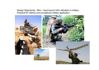
  • 81. Design Opportunity - Mini – hand launch UAV utilization in military Practical for infantry and surveillance military application
  • 82. Malaysia Design Community • Innovation, be different, do something new • Our experience in Geosense – entrepreneurial sprit + engineering – UAV a complex sys. multi disciplinary, we crash many x, a challenge to keep improve – Use other technology :( – Re-engineer, continuous improvement-learn, collaboration, – our own tech. proud :) • We are at the beginning - Long way to go
  • 83. Looking for • New ideas • Collaboration • Improvement – Endurance – Load – Sensors – Software (autopilot & image processing) • Customers
  • 84. Thanks You [email protected] +6 019 726 6411 www.geosense.com.my