SlideShare a Scribd company logo
Tools for Spatial
Conservation Planning
Flora- och Faunavård 2016
You are free to:
Icons from Creative Commons (CC-BY 3.0) and Font Awesome (SIL Open Font
License (OFL))
Provided that:
Copy, share, adapt, or re-mix
Photograph, film, or broadcast
Blog, live-blog, or post video of;
You attribute the work to its author and respect the
Rights and licenses associated with its components
Hej!
I’M JOONA LEHTOMÄKI
I come from Vrije Universiteit Amsterdam
where I work as a post-doc.
@jlehtoma jlehtoma
BACKGROUND
Introduction to spatial conservation prioritization
1
SPATIAL CONSERVATION PRIORITIZATION
Identify spatial allocation of
conservation resources (actions)
◦ Protection
◦ Management
◦ Restoration
◦ Offsetting
… and various other forms of land
use.
Species often used as biodiversity
units in conservation
Communities, processes or services
can be considered as well
Use of surrogates inevitable:
perfect information of biodiversity
not feasible
BIODIVERSITY FEATURES
Area: quantity of available habitat
Quality: density of resources (dead-
wood etc.)
Aggregation: spatial arrangement
of habitat
3 FUNDAMENTAL AXES OF SPATIAL ECOLOGY
HOW DO THE AXES AFFECT POPULATION SIZES?
Populationsize
AREA QUALITY AGGREGATION
Hodgson et al. (2009)
COMPONENTS OF WELL-INFORMED CONSERVATION
DECISION MAKING
Biodiversity (features) and their
distributions now
Threats about persistence
of features
Human conservation
preferences and objectives
Costs (economics of
conservation)
Socio-political constraints
A GENERAL FRAMEWORK FOR CONSERVATION RESOURCE
ALLOCATION
Objective
Models of distribution
From distribution to
conservation value
Alternative conservation
actions
Constraints
Solution
Implementation
Objectives drive outcome →
important to be clear and explicit about them
◦ Single objective
◦ Multi-objective (conservation is inherently
multi-objective)
“Population size > x”
“Fraction of distribution protected > x”
“Ecosystem services produced > x”
A general framework
THE OBJECTIVE
THE OBJECTIVE
A general framework
Halting biodiversity
loss
Climate change
mitigation
High-level
objectives
Low-level
objectives
Decreasing the
effects of land-use
Developing green
infrastructure
HabitatsSpecies Services Processes
Area Quality
Aggregatio
n
Models of biodiversity distribution
◦ Observed static distribution
◦ Predicted static distribution
◦ Stationary time-varying distribution
◦ Non-stationary time-varying distribution
Adding realism usually increases complexity
and requires more data and resolution
MODELS OF DISTRIBUTION
A general framework
FROM DISTRIBUTION TO CONSERVATION VALUE
A general framework
Which features are included?
What structural components does the model
include (e.g. connectivity and threats)
How are features and structural components
weighted in relation to each other?
How is aggregate conservation value
summarized across many features, space and
time?
Quantitative:
○Mathematical
○Statistical
MODEL OF CONSERVATION VALUE
Qualitative:
○Verbal
○Mental
Main factors: features, space, time
Protection (reduction of loss)
Maintenance (management to maintain
favourable conditions)
Restoration (to return closer to past more
favourable conditions or succession trajectory)
Resource allocation between several
alternative actions is not straightforward
A general framework
ALTERNATIVE CONSERVATION ACTIONS
CONSTRAINTS
A general framework
CONSTRAINTS ON
Resources
(budget, area etc.)
Actions
(what is feasible)
Knowledge
(human resources)
◦ Direct cost
◦ Opportunity cost (loss due to
lost opportunity)
◦ Cost efficiency (return on
investment)
= (sum of benefits) /
(sum of costs)
CONSERVATION COSTS
Quantitative analysis to generate solutions
Several software packages available, with
slightly different strategies
◦ Zonation
◦ Marxan (family)
◦ C-Plan
◦ ConsNet
SOLUTION
A general framework
Relevant constraints should be accounted for
when constructing a solution
Often difficult (but not impossible) to include
in a quantitative analysis
◦ Local socio-political considerations
◦ Stakeholder values and preferences
◦ Anything that is not quantitative
IMPLEMENTATION
A general framework
IMPLEMENTATION
A general framework
Knight et al. (2009)
Conservation planners toolbox
Objective
Models of distribution
From distribution to
conservation value
Alternative
conservation actions
Constraints
Solution
Implementation
GIS
Participatory GIS
Species distribution
models
Landscape simulators
Visualization tools
SCP tools
ZONATION
BACKGROUND AND
WORKING PRINCIPLES
What is it?
Zonation
Tools for spatial conservation prioritization
HISTORY
2006 2008 2012 2015
ZONATION CONSERVATION PRIORITIZATION
FRAMEWORK AND SOFTWARE
Produces a hierarchical
zoning of the landscape
aiming at biodiversity
persistence in a
balanced way.
What is it not?
Zonation
Statistical species distribution
modelling (SDM) tool
Tool designed primarily for
connectivity analysis and corridors
General purpose geographic
information system (GIS)
What does it do?
Zonation
TYPICAL QUESTIONS ADDRESSED
Identification of ecologically least
important areas for impact avoidance of
development
Evaluation of existing or proposed PAs
Zonation
Identification of ecologically most
important areas for reserve network
expansion
TYPICAL QUESTIONS ADDRESSED
Spatial allocation of habitat maintenance
and restoration
Targeting financial incentives for
conservation
Planning for biodiversity offsets
Zonation
Species often used as biodiversity
units in conservation
Communities, processes or services
can be considered as well
Use of surrogates inevitable: perfect
information of biodiversity not feasible
BIODIVERSITY FEATURES
Recap
Feature specific weights and
connectivity
MAJOR FEATURES
Can include uncertainty and costs
Species and community level prioritization
Zonation
MAJOR FEATURES
Balancing alternative land uses
Landscape condition and retention
Prioritization across administrative
regions
Zonation
How does it work?
Zonation
Cell, pixel
Raster,
grid
Polygon
LANDSCAPE
Recap
SPATIAL UNITS
INPUT DATA
Zonation
INPUT DATA: CATEGORIZATION
Zonation
Expert
knowledge
Modelled Observed,
indirect
Observed,
direct
CONSTRAINTS
Recap
CONSTRAINTS ON
Resources Actions Knowledge
Costs
(e.g. €/SEK)
Condition
(e.g. degradation)
Uncertainty
(e.g. model uncert.)
INPUT DATA
Zonation
Objectives
Models of
distribution
Selected features
Weights
Connectivity
Conservation
value
€
Constraints
Alternative
conservation
actions
Solution
Absolute value
CELL REMOVAL
Zonation algorithm
4 10 15
5 23 32
20 40 51
0.02 0.05 0.075
0.025 0.115 0.16
0.1 0.2 0.255
Normalized values
0.051 0.0765
0.0255 0.1174 0.1632
0.102 0.2041 0.2602
0.0523 0.0785
0.1204 0.1675
0.1047 0.2094 0.2670
0.0828
0.1270 0.1767
0.1104 0.2209 0.2817
0.1385 0.1927
0.1204 0.2409 0.3072
0.1575 0.2191
0.2739 0.3493
0.2601
0.3252 0.41460.4395 0.56041.0
Ranking = reverse
cell removal order
Zonation algorithm
CELL REMOVAL MULTI SPECIES
CELL REMOVAL
TERMINOLOGY
Complementarity = a measure of
the extent that different sites in a
reserve network complement each
other to achieve conservation
goals.
Zonation algorithm
CELL REMOVAL
Core-area Zonation (CAZ)
◦ Cell value is the maximum biological value
within the cell, across all features/species
◦ Somewhat emphasizes rarity
Additive benefit function (ABF)
◦ Cell value is the sum of value across species
within the cell
◦ Somewhat emphasizes richness
→ Different rules implement different
conceptions of conservation value
Zonation basic output 1
RANK PRIORITY MAP
Rank priority
Map is not a final product
Kuusterä et al. (2015)
Zonation basic output 1
RANK PRIORITY MAP
Rank priority With connectivity
Kuusterä et al. (2015)
Map is not a final product
Zonation basic output 1
RANK PRIORITY MAP
Rank priority With connectivity
and zoning areas
Kuusterä et al. (2015)
Map is not a final product
Zonation basic output 2
PERFORMANCE CURVES
Rank priority
Zonation basic output 2
PERFORMANCE CURVES
Kuusterä et al. (2015)
Map is not a final product
Zonation
BALANCING ACT
Moilanen et al. (2011)
Tools for spatial conservation prioritization
GIS OVERLAY (SCORING) vs COMPLEMENTARITY
Performance
WHAT’S THE DIFFERENCE?
GIS OVERLAY (SCORING) vs COMPLEMENTARITY
Performance
Kullberg et al. (2015)
GIS OVERLAY (SCORING) vs COMPLEMENTARITY
Performance
Kullberg et al. (2015)
Kuusterä, J., Aalto, S., Moilanen, A., Toivonen, T., & Lehtomäki, J.
(2015). Uudenmaan viherrakenteen analysointi Zonation-
menetelmällä. Helsinki, Uudenmaanliitto.
http://bit.ly/uml-zonation
Case study 1:
Planning for green infrastructure
in Uusimaa region, Finland
OBJECTIVES1
Planning for green infrastructure in Uusimaa region
“
The Regional Plan 4 for the Helsinki-
Uusimaa Region aims mainly to create
preconditions for a competitive region
offering well- being for its inhabitants,
that is not exceeding the limits of
sustainable development.
“
- Helsinki-Uusimaa Regional Council,
http://bit.ly/uml-plan4
Planning for green infrastructure in Uusimaa region
OBJECTIVES
Main themes:
1. Business and
innovation
2. Logistics
3. Wind energy
4. Green infrastructure
5. Cultural heritage
Helsinki-Uusimaa Regional Council (2015)
Green infrastructure framing and scope
◦ Biodiversity
◦ Ecological networks
◦ Recreational networks
◦ Natural resources (narrow scope)
◦ Ecosystem services (narrow scope)
→ spatial prioritization of high nature values
sites with relatively low human disturbance
Planning for green infrastructure in Uusimaa region
OBJECTIVES
MODELS OF DISTRIBUTION2
Planning for green infrastructure in Uusimaa region
1
2
3
MODELS OF DISTRIBUTION
Planning for green infrastructure in Uusimaa region
Habitat data (e.g.)
◦ Valuable forests
◦ Geodiversity
◦ Peatlands and wetlands
Species data (e.g.)
◦ Threatened species
◦ Birds
◦ Large carnivores and
game species
PAs and ecosystem
services (e.g.)
◦ Protected areas and
programmes
◦ ESS provision potential
Land-use (e.g.)
◦ Built areas
◦ Groundwater areas
◦ Land-use change
scenarios
4
Kuusterä et al. (2015)
CONSERVATION VALUE3
Planning for green infrastructure in Uusimaa region
Additive benefit function (ABF)
◦ Somewhat emphasizes richness
More weight to habitats, threatened species
Connectivity: Matrix connectivity
Division to administrative (sub) units
Planning for green infrastructure in Uusimaa region
CONSERVATION VALUE
ALTERNATIVE CONSERVATION
ACTIONS
4
Planning for green infrastructure in Uusimaa region
No direct actions, but plan designations can
later be used for targeting land-use
development
ALTERNATIVE CONSERVATION ACTIONS
Planning for green infrastructure in Uusimaa region
Kuusterä et al. (2015)
CONSTRAINTS5
Planning for green infrastructure in Uusimaa region
CONSTRAINTS
Planning for green infrastructure in Uusimaa region
1. Lowered ecological condition through land-use
2. Lowered environmental condition through
anthropogenic noise
SOLUTIONS6
Planning for green infrastructure in Uusimaa region
SOLUTION
Planning for green infrastructure in Uusimaa region
Local quality of the biodiversity features
Kuusterä et al. (2015)
SOLUTION
Planning for green infrastructure in Uusimaa region
Including land-use and connectivity
Kuusterä et al. (2015)
SOLUTION
Planning for green infrastructure in Uusimaa region
Coverageoffeature
distributions(%)
Fraction of area (%)
Protected areas in the regional plan
Poorest performing feature
Average over all features
Recreational areas in the regional plan
Best 10% inZonation analysis
Kuusterä et al. (2015)
IMPLEMENTATION7
Planning for green infrastructure in Uusimaa region
No immediate actions, results will be used in
later stages
IMPLEMENTATION
Evaluation of the proposed benthic protection areas of New Zealand
The future
◦ Other regional councils
interested as well
◦ More emphasis on
ecosystem services
Kuusterä et al. (2015)
REFERENCES
Hodgson, J. A., Thomas, C. D., Wintle, B. A., & Moilanen, A. (2009). Climate change,
connectivity and conservation decision making: back to basics. Journal of Applied
Ecology, 46(5), 964–969. http://doi.org/10.1111/j.1365-2664.2009.01695.x
Knight, A. T., Cowling, R. M., Possingham, H. P. & Wilson, K. A. (2009). From Theory
to Practice: Designing and Situating Spatial Prioritization Approaches to Better
Implement Conservation Action. In A. Moilanen, K. A. Wilson, & H. P. Possingham
(Eds.), Spatial Conservation Prioritization: Quantitative Methods & Computational
Tools (p. 304). Oxford: Oxford University Press.
Kuusterä, J., Aalto, S., Moilanen, A., Toivonen, T., & Lehtomäki, J. (2015).
Uudenmaan viherrakenteen analysointi Zonation-menetelmällä. Helsinki. URL:
http://www.uudenmaanliitto.fi/files/15491/Uudenmaan_viherrakenteen_analysointi
_Zonation-menetelmalla_E145-2015.pdf
CREDITS
Special thanks to all the people who made
and released these awesome resources for
free:
◦ Simple line icons by Mirko Monti
◦ Presentation template by SlidesCarnival
Special thanks to Atte Moilanen
Ad

Recommended

Nature-based Solutions to Climate Change
ESD UNU-IAS
 
深層学習を利用した音声強調
深層学習を利用した音声強調
Yuma Koizumi
 
Identifying, quantifying and valuing ecosystem services in the context of eco...
CIFOR-ICRAF
 
Vantaan kaupungin kiertotalouden tiekartta
Circwaste
 
Conservation Report Project 2
Yung Kai
 
Convervation Presentation Slide Project 2
Yung Kai
 
Report
Report
Yung Kai
 
ENVISION Y El Modelamiento Del Paisaje - En Ingles
Instituto Humboldt
 
Relu special session Bham planning conf_carter-schiessel-scott_13-09-2011
ruralfringe
 
What a waste of space: Can spatial planning add value to managing the environ...
Aberdeen CES
 
Overview of Ecosystem Extent and Integrity Slides
ThangLong11
 
Assignment Of Measurable Costs And Benefits To Wildlife Conservation Projects
April Smith
 
Virgilio - input2012
INPUT 2012
 
Presentation1 - Basis of application of Ecogeography in PGR
Mauricio Parra Quijano
 
A framework to assess wetlands' potential as Nature-based Solutions
AngelosAlamanos
 
Integrated LULCC modeling and impact assessment
ILRI
 
Presentation1 ecogeographic basis
Mauricio Parra Quijano
 
Assessing Environmental Sound Technologies
CC BASE
 
Scenario workshop honduras zamorano irbio 24 may 2011 wv r
Mildred_Lagos
 
Scenario workshop honduras zamorano irbio 24 may 2011 wv r
Mildred_Lagos
 
PHD -Kumar
PHD -Kumar
Parveen Kumar
 
Richard THOMAS, Mark SCHAUER "Economics of Land Degradation (ELD) Initiative ...
Global Risk Forum GRFDavos
 
Institutions for Ecosystem Services
Water, Land and Ecosystems (WLE)
 
From global to local: How can spatial conservation prioritization inform con...
jlehtoma
 
Towards a more ‘impact-oriented’ institutional M&E system:
Institute of Development Studies
 
Uwe conf spes_scott_carter_12-5-2011_publish
ruralfringe
 
Should spatial planning jump into bed with ecosystem services? New theoretica...
Aberdeen CES
 
The scientific heritage No 162 (162) (2025)
The scientific heritage
 
THE CIRCULATORY SYSTEM GRADE 9 SCIENCE.pptx
roselyncatacutan
 

More Related Content

Similar to Tools for spatial conservation prioritization (20)

ENVISION Y El Modelamiento Del Paisaje - En Ingles
Instituto Humboldt
 
Relu special session Bham planning conf_carter-schiessel-scott_13-09-2011
ruralfringe
 
What a waste of space: Can spatial planning add value to managing the environ...
Aberdeen CES
 
Overview of Ecosystem Extent and Integrity Slides
ThangLong11
 
Assignment Of Measurable Costs And Benefits To Wildlife Conservation Projects
April Smith
 
Virgilio - input2012
INPUT 2012
 
Presentation1 - Basis of application of Ecogeography in PGR
Mauricio Parra Quijano
 
A framework to assess wetlands' potential as Nature-based Solutions
AngelosAlamanos
 
Integrated LULCC modeling and impact assessment
ILRI
 
Presentation1 ecogeographic basis
Mauricio Parra Quijano
 
Assessing Environmental Sound Technologies
CC BASE
 
Scenario workshop honduras zamorano irbio 24 may 2011 wv r
Mildred_Lagos
 
Scenario workshop honduras zamorano irbio 24 may 2011 wv r
Mildred_Lagos
 
PHD -Kumar
PHD -Kumar
Parveen Kumar
 
Richard THOMAS, Mark SCHAUER "Economics of Land Degradation (ELD) Initiative ...
Global Risk Forum GRFDavos
 
Institutions for Ecosystem Services
Water, Land and Ecosystems (WLE)
 
From global to local: How can spatial conservation prioritization inform con...
jlehtoma
 
Towards a more ‘impact-oriented’ institutional M&E system:
Institute of Development Studies
 
Uwe conf spes_scott_carter_12-5-2011_publish
ruralfringe
 
Should spatial planning jump into bed with ecosystem services? New theoretica...
Aberdeen CES
 
ENVISION Y El Modelamiento Del Paisaje - En Ingles
Instituto Humboldt
 
Relu special session Bham planning conf_carter-schiessel-scott_13-09-2011
ruralfringe
 
What a waste of space: Can spatial planning add value to managing the environ...
Aberdeen CES
 
Overview of Ecosystem Extent and Integrity Slides
ThangLong11
 
Assignment Of Measurable Costs And Benefits To Wildlife Conservation Projects
April Smith
 
Virgilio - input2012
INPUT 2012
 
Presentation1 - Basis of application of Ecogeography in PGR
Mauricio Parra Quijano
 
A framework to assess wetlands' potential as Nature-based Solutions
AngelosAlamanos
 
Integrated LULCC modeling and impact assessment
ILRI
 
Assessing Environmental Sound Technologies
CC BASE
 
Scenario workshop honduras zamorano irbio 24 may 2011 wv r
Mildred_Lagos
 
Scenario workshop honduras zamorano irbio 24 may 2011 wv r
Mildred_Lagos
 
Richard THOMAS, Mark SCHAUER "Economics of Land Degradation (ELD) Initiative ...
Global Risk Forum GRFDavos
 
From global to local: How can spatial conservation prioritization inform con...
jlehtoma
 
Towards a more ‘impact-oriented’ institutional M&E system:
Institute of Development Studies
 
Uwe conf spes_scott_carter_12-5-2011_publish
ruralfringe
 
Should spatial planning jump into bed with ecosystem services? New theoretica...
Aberdeen CES
 

Recently uploaded (20)

The scientific heritage No 162 (162) (2025)
The scientific heritage
 
THE CIRCULATORY SYSTEM GRADE 9 SCIENCE.pptx
roselyncatacutan
 
242680824006, 09, 02 suoac guideline nd bacpac
091HarshikaModi
 
Science 7 DLL Week 1 Quarter 1 Matatag Curriculum
RONAFAITHLOOC
 
plant and animal nutrition..........pptx
mayflorgalleno
 
Science 8 Quarter 4 first quiz digestive system.docx
junefermunez
 
STAPHYLOCOCCAL AND STREPTOCOCCAL INFECTIONS 2.ppt
pakranti27
 
Herbal Excipients: Natural Colorants & Perfumery Agents
Seacom Skills University
 
FYJC .Chapter-14 L-1 Human Nutrition.pdf
RachanaT6
 
Overview of Stem Cells and Immune Modulation.ppsx
AhmedAtwa29
 
Lecture 9 Natural selection Evolution.pptx
madi34702
 
GBSN__Unit 2 - Control of Microorganisms
Areesha Ahmad
 
What is Research Grade 7/ Research I.pptx
delapenamhey144
 
1-SEAFLOOR-SPREADINGGGGGGGGGGGGGGGGGGGG.pptx
JohnCristoffMendoza
 
Impact of Network Topologies on Blockchain Performance
vschiavoni
 
Flexible Denture -Removable partial denture.pptx
Nekemiya
 
Sujay Rao Mandavilli public profile June 2025.pdf
Sujay Rao Mandavilli
 
Relazione di laboratorio Idrolisi dell'amido (in inglese)
paolofvesco
 
Chromatography Slides for the course of Introduction to Biology and Chemistry...
Md. Arif Shahriar
 
MEDICINAL CHEMISTRY PROSPECTIVES IN DESIGN OF EGFR INHIBITORS.pptx
40RevathiP
 
Ad

Tools for spatial conservation prioritization

  • 1. Tools for Spatial Conservation Planning Flora- och Faunavård 2016
  • 2. You are free to: Icons from Creative Commons (CC-BY 3.0) and Font Awesome (SIL Open Font License (OFL)) Provided that: Copy, share, adapt, or re-mix Photograph, film, or broadcast Blog, live-blog, or post video of; You attribute the work to its author and respect the Rights and licenses associated with its components
  • 3. Hej! I’M JOONA LEHTOMÄKI I come from Vrije Universiteit Amsterdam where I work as a post-doc. @jlehtoma jlehtoma
  • 4. BACKGROUND Introduction to spatial conservation prioritization 1
  • 5. SPATIAL CONSERVATION PRIORITIZATION Identify spatial allocation of conservation resources (actions) ◦ Protection ◦ Management ◦ Restoration ◦ Offsetting … and various other forms of land use.
  • 6. Species often used as biodiversity units in conservation Communities, processes or services can be considered as well Use of surrogates inevitable: perfect information of biodiversity not feasible BIODIVERSITY FEATURES
  • 7. Area: quantity of available habitat Quality: density of resources (dead- wood etc.) Aggregation: spatial arrangement of habitat 3 FUNDAMENTAL AXES OF SPATIAL ECOLOGY
  • 8. HOW DO THE AXES AFFECT POPULATION SIZES? Populationsize AREA QUALITY AGGREGATION Hodgson et al. (2009)
  • 9. COMPONENTS OF WELL-INFORMED CONSERVATION DECISION MAKING Biodiversity (features) and their distributions now Threats about persistence of features Human conservation preferences and objectives Costs (economics of conservation) Socio-political constraints
  • 10. A GENERAL FRAMEWORK FOR CONSERVATION RESOURCE ALLOCATION Objective Models of distribution From distribution to conservation value Alternative conservation actions Constraints Solution Implementation
  • 11. Objectives drive outcome → important to be clear and explicit about them ◦ Single objective ◦ Multi-objective (conservation is inherently multi-objective) “Population size > x” “Fraction of distribution protected > x” “Ecosystem services produced > x” A general framework THE OBJECTIVE
  • 12. THE OBJECTIVE A general framework Halting biodiversity loss Climate change mitigation High-level objectives Low-level objectives Decreasing the effects of land-use Developing green infrastructure HabitatsSpecies Services Processes Area Quality Aggregatio n
  • 13. Models of biodiversity distribution ◦ Observed static distribution ◦ Predicted static distribution ◦ Stationary time-varying distribution ◦ Non-stationary time-varying distribution Adding realism usually increases complexity and requires more data and resolution MODELS OF DISTRIBUTION A general framework
  • 14. FROM DISTRIBUTION TO CONSERVATION VALUE A general framework Which features are included? What structural components does the model include (e.g. connectivity and threats) How are features and structural components weighted in relation to each other? How is aggregate conservation value summarized across many features, space and time?
  • 15. Quantitative: ○Mathematical ○Statistical MODEL OF CONSERVATION VALUE Qualitative: ○Verbal ○Mental Main factors: features, space, time
  • 16. Protection (reduction of loss) Maintenance (management to maintain favourable conditions) Restoration (to return closer to past more favourable conditions or succession trajectory) Resource allocation between several alternative actions is not straightforward A general framework ALTERNATIVE CONSERVATION ACTIONS
  • 17. CONSTRAINTS A general framework CONSTRAINTS ON Resources (budget, area etc.) Actions (what is feasible) Knowledge (human resources)
  • 18. ◦ Direct cost ◦ Opportunity cost (loss due to lost opportunity) ◦ Cost efficiency (return on investment) = (sum of benefits) / (sum of costs) CONSERVATION COSTS
  • 19. Quantitative analysis to generate solutions Several software packages available, with slightly different strategies ◦ Zonation ◦ Marxan (family) ◦ C-Plan ◦ ConsNet SOLUTION A general framework
  • 20. Relevant constraints should be accounted for when constructing a solution Often difficult (but not impossible) to include in a quantitative analysis ◦ Local socio-political considerations ◦ Stakeholder values and preferences ◦ Anything that is not quantitative IMPLEMENTATION A general framework
  • 22. Conservation planners toolbox Objective Models of distribution From distribution to conservation value Alternative conservation actions Constraints Solution Implementation GIS Participatory GIS Species distribution models Landscape simulators Visualization tools SCP tools
  • 27. ZONATION CONSERVATION PRIORITIZATION FRAMEWORK AND SOFTWARE Produces a hierarchical zoning of the landscape aiming at biodiversity persistence in a balanced way.
  • 28. What is it not? Zonation
  • 29. Statistical species distribution modelling (SDM) tool Tool designed primarily for connectivity analysis and corridors General purpose geographic information system (GIS)
  • 30. What does it do? Zonation
  • 31. TYPICAL QUESTIONS ADDRESSED Identification of ecologically least important areas for impact avoidance of development Evaluation of existing or proposed PAs Zonation Identification of ecologically most important areas for reserve network expansion
  • 32. TYPICAL QUESTIONS ADDRESSED Spatial allocation of habitat maintenance and restoration Targeting financial incentives for conservation Planning for biodiversity offsets Zonation
  • 33. Species often used as biodiversity units in conservation Communities, processes or services can be considered as well Use of surrogates inevitable: perfect information of biodiversity not feasible BIODIVERSITY FEATURES Recap
  • 34. Feature specific weights and connectivity MAJOR FEATURES Can include uncertainty and costs Species and community level prioritization Zonation
  • 35. MAJOR FEATURES Balancing alternative land uses Landscape condition and retention Prioritization across administrative regions Zonation
  • 36. How does it work? Zonation
  • 40. CONSTRAINTS Recap CONSTRAINTS ON Resources Actions Knowledge Costs (e.g. €/SEK) Condition (e.g. degradation) Uncertainty (e.g. model uncert.)
  • 41. INPUT DATA Zonation Objectives Models of distribution Selected features Weights Connectivity Conservation value € Constraints Alternative conservation actions Solution
  • 42. Absolute value CELL REMOVAL Zonation algorithm 4 10 15 5 23 32 20 40 51 0.02 0.05 0.075 0.025 0.115 0.16 0.1 0.2 0.255 Normalized values 0.051 0.0765 0.0255 0.1174 0.1632 0.102 0.2041 0.2602 0.0523 0.0785 0.1204 0.1675 0.1047 0.2094 0.2670 0.0828 0.1270 0.1767 0.1104 0.2209 0.2817 0.1385 0.1927 0.1204 0.2409 0.3072 0.1575 0.2191 0.2739 0.3493 0.2601 0.3252 0.41460.4395 0.56041.0 Ranking = reverse cell removal order
  • 43. Zonation algorithm CELL REMOVAL MULTI SPECIES CELL REMOVAL
  • 44. TERMINOLOGY Complementarity = a measure of the extent that different sites in a reserve network complement each other to achieve conservation goals.
  • 45. Zonation algorithm CELL REMOVAL Core-area Zonation (CAZ) ◦ Cell value is the maximum biological value within the cell, across all features/species ◦ Somewhat emphasizes rarity Additive benefit function (ABF) ◦ Cell value is the sum of value across species within the cell ◦ Somewhat emphasizes richness → Different rules implement different conceptions of conservation value
  • 46. Zonation basic output 1 RANK PRIORITY MAP Rank priority Map is not a final product Kuusterä et al. (2015)
  • 47. Zonation basic output 1 RANK PRIORITY MAP Rank priority With connectivity Kuusterä et al. (2015) Map is not a final product
  • 48. Zonation basic output 1 RANK PRIORITY MAP Rank priority With connectivity and zoning areas Kuusterä et al. (2015) Map is not a final product
  • 49. Zonation basic output 2 PERFORMANCE CURVES
  • 50. Rank priority Zonation basic output 2 PERFORMANCE CURVES Kuusterä et al. (2015) Map is not a final product
  • 53. GIS OVERLAY (SCORING) vs COMPLEMENTARITY Performance WHAT’S THE DIFFERENCE?
  • 54. GIS OVERLAY (SCORING) vs COMPLEMENTARITY Performance Kullberg et al. (2015)
  • 55. GIS OVERLAY (SCORING) vs COMPLEMENTARITY Performance Kullberg et al. (2015)
  • 56. Kuusterä, J., Aalto, S., Moilanen, A., Toivonen, T., & Lehtomäki, J. (2015). Uudenmaan viherrakenteen analysointi Zonation- menetelmällä. Helsinki, Uudenmaanliitto. http://bit.ly/uml-zonation Case study 1: Planning for green infrastructure in Uusimaa region, Finland
  • 57. OBJECTIVES1 Planning for green infrastructure in Uusimaa region
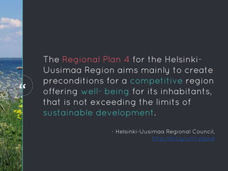
  • 58. “ The Regional Plan 4 for the Helsinki- Uusimaa Region aims mainly to create preconditions for a competitive region offering well- being for its inhabitants, that is not exceeding the limits of sustainable development. “ - Helsinki-Uusimaa Regional Council, http://bit.ly/uml-plan4
  • 59. Planning for green infrastructure in Uusimaa region OBJECTIVES Main themes: 1. Business and innovation 2. Logistics 3. Wind energy 4. Green infrastructure 5. Cultural heritage Helsinki-Uusimaa Regional Council (2015)
  • 60. Green infrastructure framing and scope ◦ Biodiversity ◦ Ecological networks ◦ Recreational networks ◦ Natural resources (narrow scope) ◦ Ecosystem services (narrow scope) → spatial prioritization of high nature values sites with relatively low human disturbance Planning for green infrastructure in Uusimaa region OBJECTIVES
  • 61. MODELS OF DISTRIBUTION2 Planning for green infrastructure in Uusimaa region
  • 62. 1 2 3 MODELS OF DISTRIBUTION Planning for green infrastructure in Uusimaa region Habitat data (e.g.) ◦ Valuable forests ◦ Geodiversity ◦ Peatlands and wetlands Species data (e.g.) ◦ Threatened species ◦ Birds ◦ Large carnivores and game species PAs and ecosystem services (e.g.) ◦ Protected areas and programmes ◦ ESS provision potential Land-use (e.g.) ◦ Built areas ◦ Groundwater areas ◦ Land-use change scenarios 4
  • 64. CONSERVATION VALUE3 Planning for green infrastructure in Uusimaa region
  • 65. Additive benefit function (ABF) ◦ Somewhat emphasizes richness More weight to habitats, threatened species Connectivity: Matrix connectivity Division to administrative (sub) units Planning for green infrastructure in Uusimaa region CONSERVATION VALUE
  • 66. ALTERNATIVE CONSERVATION ACTIONS 4 Planning for green infrastructure in Uusimaa region
  • 67. No direct actions, but plan designations can later be used for targeting land-use development ALTERNATIVE CONSERVATION ACTIONS Planning for green infrastructure in Uusimaa region Kuusterä et al. (2015)
  • 68. CONSTRAINTS5 Planning for green infrastructure in Uusimaa region
  • 69. CONSTRAINTS Planning for green infrastructure in Uusimaa region 1. Lowered ecological condition through land-use 2. Lowered environmental condition through anthropogenic noise
  • 70. SOLUTIONS6 Planning for green infrastructure in Uusimaa region
  • 71. SOLUTION Planning for green infrastructure in Uusimaa region Local quality of the biodiversity features Kuusterä et al. (2015)
  • 72. SOLUTION Planning for green infrastructure in Uusimaa region Including land-use and connectivity Kuusterä et al. (2015)
  • 73. SOLUTION Planning for green infrastructure in Uusimaa region Coverageoffeature distributions(%) Fraction of area (%) Protected areas in the regional plan Poorest performing feature Average over all features Recreational areas in the regional plan Best 10% inZonation analysis Kuusterä et al. (2015)
  • 74. IMPLEMENTATION7 Planning for green infrastructure in Uusimaa region
  • 75. No immediate actions, results will be used in later stages IMPLEMENTATION Evaluation of the proposed benthic protection areas of New Zealand The future ◦ Other regional councils interested as well ◦ More emphasis on ecosystem services
  • 77. REFERENCES Hodgson, J. A., Thomas, C. D., Wintle, B. A., & Moilanen, A. (2009). Climate change, connectivity and conservation decision making: back to basics. Journal of Applied Ecology, 46(5), 964–969. http://doi.org/10.1111/j.1365-2664.2009.01695.x Knight, A. T., Cowling, R. M., Possingham, H. P. & Wilson, K. A. (2009). From Theory to Practice: Designing and Situating Spatial Prioritization Approaches to Better Implement Conservation Action. In A. Moilanen, K. A. Wilson, & H. P. Possingham (Eds.), Spatial Conservation Prioritization: Quantitative Methods & Computational Tools (p. 304). Oxford: Oxford University Press. Kuusterä, J., Aalto, S., Moilanen, A., Toivonen, T., & Lehtomäki, J. (2015). Uudenmaan viherrakenteen analysointi Zonation-menetelmällä. Helsinki. URL: http://www.uudenmaanliitto.fi/files/15491/Uudenmaan_viherrakenteen_analysointi _Zonation-menetelmalla_E145-2015.pdf
  • 78. CREDITS Special thanks to all the people who made and released these awesome resources for free: ◦ Simple line icons by Mirko Monti ◦ Presentation template by SlidesCarnival Special thanks to Atte Moilanen