SlideShare a Scribd company logo
9th July 2025
Sanghee Shin, CEO of Gaia3D, Inc.
shshin@gaia3d.com
The GeoSpatial Company
Building Resilience with Digital Twins :
Lessons from Korea
[ TCS x UNDRR Conference | Kobe, Japan | July 7–9, 2025 ]
Company Info.
Company Name Gaia3D, Inc.
Founder & CEO Sanghee Shin
Established November 1st 2000
Homepage www.gaia3d.com
Business Area Digital Twin/Space/Satellite/Earth Science/Weather Software
Development and Solutions Providing
H.Q. #313, 65 Techno 3-ro, Yuseong-gu, Daejeon, Korea
Phone / +82-42-330-0400
Seoul #610, 68 Digital-ro 9-gil, Geumcheon-gu, Seoul, Korea
Phone / +82-2-837-3475
- 2 -
Characteristics of South Korea
- 3 -
South Korea's urbanization
rate is 90.7%, well above
the global average.
Frequent wildfires and
landslides.
Coastal flooding and
typhoon risks.
High concentration of
infrastructure and assets.
<Source: OpenStreetMap Tracestrack>
Why This Matters: Addressing the Disasters
Climate Change
1
The climate crisis is intensifying extreme weather events—bringing heavier rainfall, longer
heatwaves, and more frequent storms.
Limits of Traditional Systems
3
Existing disaster response mechanisms are struggling to cope with the scale and complexity
of these new threats, highlighting an urgent need for advanced solutions.
Rapid Urbanization
2
Meanwhile, rapid urbanization increases vulnerability by concentrating populations and
Infrastructure in hazard-prone areas, often without adequate planning.
Need for Proactive Solutions
4
We require innovative, digital, and collaborative approaches to predict, prevent, and respond
to disasters more effectively, safeguarding lives and infrastructure.
- 4 -
Main Principles for the Digital Twin Implementations
- 5 -
Accessibility and sharing of critical urban and
environmental data are fundamental for informed
decision-making and collaborative innovation.
Utilizing open-source technologies ensures
transparency, fosters community-driven
development, and reduces proprietary
dependencies for wider adoption.
Our solutions are designed to be easily scalable to
accommodate the needs of diverse cities and
regions globally with well known open
architecture.
Open Source Open Architecture
Open standards guarantees interoperability
between diverse systems and data formats,
promoting seamless integration and scalability.
Open Standards
Open Data
Digital Twin System Architecture
- 6 -
• Web based disaster management digital twin
• International OGC(Open Geospatial Consortium) standards compliant & open source based architecture
• In-house data converter for simulation data visualization
External
Disaster Simulation
Attributes&
Metadata
Geospatial Data – Overall
- 7 -
Buildings (LOD 1.0) =< 22Millions
Terrain (5m DEM & 1m DEM)
Other Data
• Road and related facilities
• Administrative Boundary
• Schools, Government Buildings
• Parcels and others
Geospatial Data – Buildings
2D footprint building data
with height info.
Extruding 2D buildings to 3D using building height.
Converting 3D buildings to OGC 3D Tiles for web service
Digital Twin service through web
• Converting 22M 2D buildings
to 3D Tiles for web based
digital twin service!
- 8 -
1
2
3
Geospatial Data – External Thematic Maps Integration
- 9 -
• Integration of external public data such as the Landslide Hazard Map, Inundation Trace Map, and River
Floodplain Maps (National/Local) through OGC standards.
Case Study - Advanced Urban Flood Management
- 10 -
• UI for setting the Target Area, Rainfall
Return Period, and Rainfall Duration
• Providing information on: Total
Rainfall, Inundated Area, and
Estimated Affected Population
Case Study - Advanced Urban Flood Management
- 11 -
• View Estimated Inundation Depth per
building.
• Retrieve detailed building information
from other public government system.
Case Study – Urban Steep Slope Management
- 12 -
• Looking up Steep Slope Locations and
management details.
• Managing Inspection Records, including
adding new entries.
Case Study – Urban Steep Slope Management
- 13 -
• View inspection files during safety check
• View various on-site data, including
photos, Street View, and point clouds.
Case Study – Urban Flood & Steep Slope Management
- 14 -
Case Study – Landslide Simulation & Management
- 15 -
• Simulating a landslide with and without a
debris barrier.
• Estimating the potential impact, including
the affected area and properties.
Case Study – Landslide Simulation & Management
- 16 -
Case Study – Chemical Accident Simulation & Response
- 17 -
Pre-Event During Event Post Event
Proactive Risk Assessment &
Planning
Real-Time Emergency
Response Support
Post-Incident Analysis &
Damage Assessment
To identify worst-case scenarios and high-
risk conditions by simulating various
chemicals under diverse weather patterns.
To provide immediate, actionable
intelligence and decision support for rapid
and effective response during an actual
incident.
To accurately determine the precise
impact area and affected population for
fair compensation and forensic analysis of
past events.
Case Study – Chemical Accident Simulation & Response
- 18 -
Key Success Factors for Digital Twin Implementation
- 19 -
Purpose-Centric System
Designing intuitive, user-friendly interfaces ensures that users and first responders
can easily access and utilize critical information during emergencies.
Successful implementation requires seamless collaboration and data exchange between
various government agencies and private sector partners.
Leveraging and integrating diverse public datasets, from meteorological to
infrastructure information, is crucial for comprehensive situational awareness.
Adopting open standards and interoperable technologies prevents vendor
lock-in and promotes flexibility, scalability, and broad adoption of solutions.
S
U
C
C
E
S
S
K
E
Y
1
Cross-Agency Collaboration
2
Public Data Integration
3
Open & Interoperable Tech
4
Sanghee Shin shshin@gaia3d.com
Questions?
Thank you!
The GeoSpatial Company
Web: www.gaia3d.com
YouTube: https://www.youtube.com/@mago3d890
Facebook: https://www.facebook.com/Gaia3d
X(Twitter): https://twitter.com/Gaia3D
Github: https://github.com/Gaia3D/

More Related Content

Similar to Building Resilience with Digital Twins : Lessons from Korea (20)

PDF
2013 Energy Track, Global Trends Driving the Integration of Geospatial and BI...
GIS in the Rockies
 
PPTX
Golden Age of Geospatial Data Science
George Percivall
 
PDF
Digital Revolution - Driving Construction Excellence
SNC-Lavalin
 
PPTX
CD December 2015 Le Geosystems Cable Detection presentation
Comit Projects Ltd
 
PDF
United Utilities and GIS
Esri UK
 
PDF
6G: Potential Use Cases and Enabling Technologies
3G4G
 
PDF
Projects control managment
gisystemsint
 
PDF
IOT BASED LANDSLIDE DETECTION
IRJET Journal
 
PPTX
Reasons to switch to geographic information system (gis) for civil engineering
NI BT
 
PPTX
Flood and rainfall predction final
City University
 
PDF
Stories from the FME Grant Program
Safe Software
 
PDF
TCDDM
LokoelDavid
 
PDF
React’s suitability to develop Geospatial solutions.pdf
Mindfire LLC
 
PDF
The Peak of Data Integration Encore- Navigating Climate Change with Data Inno...
Safe Software
 
PDF
Executive Leaders Forum. Drone Powered Solutions
PwC Polska
 
PPTX
Emnotion 2016
Maryna Tarasenko
 
PDF
Hazards Reporting Based On Real-Time Field Data Collection Using Personal Mob...
IJARIIT
 
PDF
A Review of _Urban Water Networks Management Using GIS
IRJET Journal
 
PDF
DAY2_4.1_Jesper Vauvert_Digitalisation in EE_EN.pdf
DuongKienTrung1
 
PDF
Singapore 3D Map for a Smart Nation
Monica Moran
 
2013 Energy Track, Global Trends Driving the Integration of Geospatial and BI...
GIS in the Rockies
 
Golden Age of Geospatial Data Science
George Percivall
 
Digital Revolution - Driving Construction Excellence
SNC-Lavalin
 
CD December 2015 Le Geosystems Cable Detection presentation
Comit Projects Ltd
 
United Utilities and GIS
Esri UK
 
6G: Potential Use Cases and Enabling Technologies
3G4G
 
Projects control managment
gisystemsint
 
IOT BASED LANDSLIDE DETECTION
IRJET Journal
 
Reasons to switch to geographic information system (gis) for civil engineering
NI BT
 
Flood and rainfall predction final
City University
 
Stories from the FME Grant Program
Safe Software
 
React’s suitability to develop Geospatial solutions.pdf
Mindfire LLC
 
The Peak of Data Integration Encore- Navigating Climate Change with Data Inno...
Safe Software
 
Executive Leaders Forum. Drone Powered Solutions
PwC Polska
 
Emnotion 2016
Maryna Tarasenko
 
Hazards Reporting Based On Real-Time Field Data Collection Using Personal Mob...
IJARIIT
 
A Review of _Urban Water Networks Management Using GIS
IRJET Journal
 
DAY2_4.1_Jesper Vauvert_Digitalisation in EE_EN.pdf
DuongKienTrung1
 
Singapore 3D Map for a Smart Nation
Monica Moran
 

More from SANGHEE SHIN (20)

PDF
How to Visualize the ​Spatio-Temporal Data Using CesiumJS​
SANGHEE SHIN
 
PDF
대한민국 대표 오픈소스, mago3DTiler의 현재와 미래 - 대한공간정보학회 2025년 신년학술대회 발표자료
SANGHEE SHIN
 
PDF
State of mago3DTiler, an open source based OGC 3D Tiles creator
SANGHEE SHIN
 
PDF
[벤틀리시스템즈코리아 사용자세미나]세슘(Cesium) 제품과 디지털트윈 구현 사례
SANGHEE SHIN
 
PDF
디지털트윈 시공간 현상 정보 가시화 사례와 과제 - 한국지도학회 2024년 춘계학술대회 발표 자료
SANGHEE SHIN
 
PDF
Building a Digital Twin Service in 10 Minutes with FOSS4G! - 오픈소스로 10분만에 디지털트...
SANGHEE SHIN
 
PDF
Do we need a new standard for visualizing the invisible?
SANGHEE SHIN
 
PDF
디지털트윈 몇몇 기술 동향과 사례 - 대한공간정보학회 신년학술대회 발표 자료
SANGHEE SHIN
 
PDF
오픈소스로 사업하기 - 가이아쓰리디 이야기(서울시립대학교 창업지원단 특강)
SANGHEE SHIN
 
PDF
FOSS4G 2023 Prizren 참가기
SANGHEE SHIN
 
PDF
책 "제품의 탄생" 소개
SANGHEE SHIN
 
PDF
공간정보 최근 동향과 디지털트윈, 메타버스
SANGHEE SHIN
 
PDF
재테크 2주일만 하면 신상희만큼 한다!
SANGHEE SHIN
 
PDF
다분야 공동활용 디지털 플랫폼 사례 공유
SANGHEE SHIN
 
PDF
공간정보 관점에서 바라본 디지털트윈과 메타버스
SANGHEE SHIN
 
PDF
FOSS4G Firenze 2022 참가기
SANGHEE SHIN
 
PDF
공간정보와 도시 디지털트윈(부산DX컨퍼런스 발표자료)
SANGHEE SHIN
 
PDF
공간정보 최근 동향과 디지털트윈, 메타버스
SANGHEE SHIN
 
PDF
디지털트윈, 스마트시티, 메타버스
SANGHEE SHIN
 
PDF
디지털 트윈(Digital Twin) - 도시와 공간정보 관점에서
SANGHEE SHIN
 
How to Visualize the ​Spatio-Temporal Data Using CesiumJS​
SANGHEE SHIN
 
대한민국 대표 오픈소스, mago3DTiler의 현재와 미래 - 대한공간정보학회 2025년 신년학술대회 발표자료
SANGHEE SHIN
 
State of mago3DTiler, an open source based OGC 3D Tiles creator
SANGHEE SHIN
 
[벤틀리시스템즈코리아 사용자세미나]세슘(Cesium) 제품과 디지털트윈 구현 사례
SANGHEE SHIN
 
디지털트윈 시공간 현상 정보 가시화 사례와 과제 - 한국지도학회 2024년 춘계학술대회 발표 자료
SANGHEE SHIN
 
Building a Digital Twin Service in 10 Minutes with FOSS4G! - 오픈소스로 10분만에 디지털트...
SANGHEE SHIN
 
Do we need a new standard for visualizing the invisible?
SANGHEE SHIN
 
디지털트윈 몇몇 기술 동향과 사례 - 대한공간정보학회 신년학술대회 발표 자료
SANGHEE SHIN
 
오픈소스로 사업하기 - 가이아쓰리디 이야기(서울시립대학교 창업지원단 특강)
SANGHEE SHIN
 
FOSS4G 2023 Prizren 참가기
SANGHEE SHIN
 
책 "제품의 탄생" 소개
SANGHEE SHIN
 
공간정보 최근 동향과 디지털트윈, 메타버스
SANGHEE SHIN
 
재테크 2주일만 하면 신상희만큼 한다!
SANGHEE SHIN
 
다분야 공동활용 디지털 플랫폼 사례 공유
SANGHEE SHIN
 
공간정보 관점에서 바라본 디지털트윈과 메타버스
SANGHEE SHIN
 
FOSS4G Firenze 2022 참가기
SANGHEE SHIN
 
공간정보와 도시 디지털트윈(부산DX컨퍼런스 발표자료)
SANGHEE SHIN
 
공간정보 최근 동향과 디지털트윈, 메타버스
SANGHEE SHIN
 
디지털트윈, 스마트시티, 메타버스
SANGHEE SHIN
 
디지털 트윈(Digital Twin) - 도시와 공간정보 관점에서
SANGHEE SHIN
 
Ad

Recently uploaded (20)

PDF
Generative AI vs Predictive AI-The Ultimate Comparison Guide
Lily Clark
 
PDF
Basics of Electronics for IOT(actuators ,microcontroller etc..)
arnavmanesh
 
PPTX
AI in Daily Life: How Artificial Intelligence Helps Us Every Day
vanshrpatil7
 
PDF
Lecture A - AI Workflows for Banking.pdf
Dr. LAM Yat-fai (林日辉)
 
PDF
Tea4chat - another LLM Project by Kerem Atam
a0m0rajab1
 
PDF
CIFDAQ's Market Wrap : Bears Back in Control?
CIFDAQ
 
PPTX
Agile Chennai 18-19 July 2025 | Workshop - Enhancing Agile Collaboration with...
AgileNetwork
 
PPTX
Agentic AI in Healthcare Driving the Next Wave of Digital Transformation
danielle hunter
 
PDF
SalesForce Managed Services Benefits (1).pdf
TechForce Services
 
PDF
Make GenAI investments go further with the Dell AI Factory
Principled Technologies
 
PPTX
Dev Dives: Automate, test, and deploy in one place—with Unified Developer Exp...
AndreeaTom
 
PDF
RAT Builders - How to Catch Them All [DeepSec 2024]
malmoeb
 
PDF
Per Axbom: The spectacular lies of maps
Nexer Digital
 
PDF
Responsible AI and AI Ethics - By Sylvester Ebhonu
Sylvester Ebhonu
 
PDF
The Future of Artificial Intelligence (AI)
Mukul
 
PPTX
PCU Keynote at IEEE World Congress on Services 250710.pptx
Ramesh Jain
 
PDF
The Future of Mobile Is Context-Aware—Are You Ready?
iProgrammer Solutions Private Limited
 
PPTX
The Future of AI & Machine Learning.pptx
pritsen4700
 
PDF
MASTERDECK GRAPHSUMMIT SYDNEY (Public).pdf
Neo4j
 
PDF
The Past, Present & Future of Kenya's Digital Transformation
Moses Kemibaro
 
Generative AI vs Predictive AI-The Ultimate Comparison Guide
Lily Clark
 
Basics of Electronics for IOT(actuators ,microcontroller etc..)
arnavmanesh
 
AI in Daily Life: How Artificial Intelligence Helps Us Every Day
vanshrpatil7
 
Lecture A - AI Workflows for Banking.pdf
Dr. LAM Yat-fai (林日辉)
 
Tea4chat - another LLM Project by Kerem Atam
a0m0rajab1
 
CIFDAQ's Market Wrap : Bears Back in Control?
CIFDAQ
 
Agile Chennai 18-19 July 2025 | Workshop - Enhancing Agile Collaboration with...
AgileNetwork
 
Agentic AI in Healthcare Driving the Next Wave of Digital Transformation
danielle hunter
 
SalesForce Managed Services Benefits (1).pdf
TechForce Services
 
Make GenAI investments go further with the Dell AI Factory
Principled Technologies
 
Dev Dives: Automate, test, and deploy in one place—with Unified Developer Exp...
AndreeaTom
 
RAT Builders - How to Catch Them All [DeepSec 2024]
malmoeb
 
Per Axbom: The spectacular lies of maps
Nexer Digital
 
Responsible AI and AI Ethics - By Sylvester Ebhonu
Sylvester Ebhonu
 
The Future of Artificial Intelligence (AI)
Mukul
 
PCU Keynote at IEEE World Congress on Services 250710.pptx
Ramesh Jain
 
The Future of Mobile Is Context-Aware—Are You Ready?
iProgrammer Solutions Private Limited
 
The Future of AI & Machine Learning.pptx
pritsen4700
 
MASTERDECK GRAPHSUMMIT SYDNEY (Public).pdf
Neo4j
 
The Past, Present & Future of Kenya's Digital Transformation
Moses Kemibaro
 
Ad

Building Resilience with Digital Twins : Lessons from Korea

  • 1. 9th July 2025 Sanghee Shin, CEO of Gaia3D, Inc. [email protected] The GeoSpatial Company Building Resilience with Digital Twins : Lessons from Korea [ TCS x UNDRR Conference | Kobe, Japan | July 7–9, 2025 ]
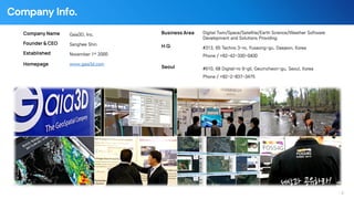
  • 2. Company Info. Company Name Gaia3D, Inc. Founder & CEO Sanghee Shin Established November 1st 2000 Homepage www.gaia3d.com Business Area Digital Twin/Space/Satellite/Earth Science/Weather Software Development and Solutions Providing H.Q. #313, 65 Techno 3-ro, Yuseong-gu, Daejeon, Korea Phone / +82-42-330-0400 Seoul #610, 68 Digital-ro 9-gil, Geumcheon-gu, Seoul, Korea Phone / +82-2-837-3475 - 2 -
  • 3. Characteristics of South Korea - 3 - South Korea's urbanization rate is 90.7%, well above the global average. Frequent wildfires and landslides. Coastal flooding and typhoon risks. High concentration of infrastructure and assets. <Source: OpenStreetMap Tracestrack>
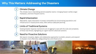
  • 4. Why This Matters: Addressing the Disasters Climate Change 1 The climate crisis is intensifying extreme weather events—bringing heavier rainfall, longer heatwaves, and more frequent storms. Limits of Traditional Systems 3 Existing disaster response mechanisms are struggling to cope with the scale and complexity of these new threats, highlighting an urgent need for advanced solutions. Rapid Urbanization 2 Meanwhile, rapid urbanization increases vulnerability by concentrating populations and Infrastructure in hazard-prone areas, often without adequate planning. Need for Proactive Solutions 4 We require innovative, digital, and collaborative approaches to predict, prevent, and respond to disasters more effectively, safeguarding lives and infrastructure. - 4 -
  • 5. Main Principles for the Digital Twin Implementations - 5 - Accessibility and sharing of critical urban and environmental data are fundamental for informed decision-making and collaborative innovation. Utilizing open-source technologies ensures transparency, fosters community-driven development, and reduces proprietary dependencies for wider adoption. Our solutions are designed to be easily scalable to accommodate the needs of diverse cities and regions globally with well known open architecture. Open Source Open Architecture Open standards guarantees interoperability between diverse systems and data formats, promoting seamless integration and scalability. Open Standards Open Data
  • 6. Digital Twin System Architecture - 6 - • Web based disaster management digital twin • International OGC(Open Geospatial Consortium) standards compliant & open source based architecture • In-house data converter for simulation data visualization External Disaster Simulation Attributes& Metadata
  • 7. Geospatial Data – Overall - 7 - Buildings (LOD 1.0) =< 22Millions Terrain (5m DEM & 1m DEM) Other Data • Road and related facilities • Administrative Boundary • Schools, Government Buildings • Parcels and others
  • 8. Geospatial Data – Buildings 2D footprint building data with height info. Extruding 2D buildings to 3D using building height. Converting 3D buildings to OGC 3D Tiles for web service Digital Twin service through web • Converting 22M 2D buildings to 3D Tiles for web based digital twin service! - 8 - 1 2 3
  • 9. Geospatial Data – External Thematic Maps Integration - 9 - • Integration of external public data such as the Landslide Hazard Map, Inundation Trace Map, and River Floodplain Maps (National/Local) through OGC standards.
  • 10. Case Study - Advanced Urban Flood Management - 10 - • UI for setting the Target Area, Rainfall Return Period, and Rainfall Duration • Providing information on: Total Rainfall, Inundated Area, and Estimated Affected Population
  • 11. Case Study - Advanced Urban Flood Management - 11 - • View Estimated Inundation Depth per building. • Retrieve detailed building information from other public government system.
  • 12. Case Study – Urban Steep Slope Management - 12 - • Looking up Steep Slope Locations and management details. • Managing Inspection Records, including adding new entries.
  • 13. Case Study – Urban Steep Slope Management - 13 - • View inspection files during safety check • View various on-site data, including photos, Street View, and point clouds.
  • 14. Case Study – Urban Flood & Steep Slope Management - 14 -
  • 15. Case Study – Landslide Simulation & Management - 15 - • Simulating a landslide with and without a debris barrier. • Estimating the potential impact, including the affected area and properties.
  • 16. Case Study – Landslide Simulation & Management - 16 -
  • 17. Case Study – Chemical Accident Simulation & Response - 17 - Pre-Event During Event Post Event Proactive Risk Assessment & Planning Real-Time Emergency Response Support Post-Incident Analysis & Damage Assessment To identify worst-case scenarios and high- risk conditions by simulating various chemicals under diverse weather patterns. To provide immediate, actionable intelligence and decision support for rapid and effective response during an actual incident. To accurately determine the precise impact area and affected population for fair compensation and forensic analysis of past events.
  • 18. Case Study – Chemical Accident Simulation & Response - 18 -
  • 19. Key Success Factors for Digital Twin Implementation - 19 - Purpose-Centric System Designing intuitive, user-friendly interfaces ensures that users and first responders can easily access and utilize critical information during emergencies. Successful implementation requires seamless collaboration and data exchange between various government agencies and private sector partners. Leveraging and integrating diverse public datasets, from meteorological to infrastructure information, is crucial for comprehensive situational awareness. Adopting open standards and interoperable technologies prevents vendor lock-in and promotes flexibility, scalability, and broad adoption of solutions. S U C C E S S K E Y 1 Cross-Agency Collaboration 2 Public Data Integration 3 Open & Interoperable Tech 4
  • 20. Sanghee Shin [email protected] Questions? Thank you! The GeoSpatial Company Web: www.gaia3d.com YouTube: https://www.youtube.com/@mago3d890 Facebook: https://www.facebook.com/Gaia3d X(Twitter): https://twitter.com/Gaia3D Github: https://github.com/Gaia3D/