SlideShare a Scribd company logo
Earth Observation Systems
Evolution from ERS & ENVISATI
to GMES.
Road-Map towards 3rd
Generation RADAR Observation
Systems OPEN
2003:
MARS EXPRESS
2003:
MARS EXPRESS
1991: ERS-1
1995: ERS-2
1991: ERS-1
1995: ERS-2
1994:
April SRL-1
October SRL-2
1994:
April SRL-1
October SRL-2
1997: CASSINI1997: CASSINI
2000: SRTM2000: SRTM
2002: ENVISAT2002: ENVISAT 2005: MRO2005: MRO
2007: COSMO-SkyMed2007: COSMO-SkyMed
Thales Alenia Space: 30 years
Excellence
in Space Radars
2013:
KOMPSAT
2013:
KOMPSAT
27 July 1991
27 July 1991 7 March 2000
7 March 2000
45200 orbits
45200 orbits
1.4 million SAR scenes
3500 scientists
using the data
3500 scientists
using the data
A major EO milestone:
ERS-1 & SAR Interferometry
ERS-1 differential interferometry reaches
the cm precision («Bonn experiment»)
Demonstration with Landers earthquake
A major EO milestone:
ERS-1 & SAR Interferometry
ERS-1 differential interferometry reaches
the cm precision («Bonn experiment»)
Demonstration with Landers earthquake
ERS 1&2 (1991-2000): an European
Success
Arctic 2007
Hurricane
Katrina
B-15A
iceberg
Bam earthquake
Ozone hole 2003
Global air
pollution
Prestige tanker
oil slick
Dec 02
Validation
Workshop
Nov 03
MERIS Workshop
Calibration Review
Sep 02
First images
Mar 02
Launch
~2200
scientific
projects
Sep 04
Envisat
Symposium
Salzburg (A)
Sep 05
MERIS
(A)ATSR
W
orkshop
Dec 03
InSAR
Workshop
Chlorophyll
concentration
Dec 05
InSAR
W
orkshop
Mar 06
Altim
etry
Conference
+ several GMES
pre-operational
projects
May 06
Atm
ospheric
Science
Conference
Envisat
Symposium
Montreux (CH)
Apr 07
CO2 map
Dec 07
InSAR
W
orkshop
C-Band Advanced
SAR
H/V polarisation
capability
active antenna
array
C-Band Advanced
SAR
H/V polarisation
capability
active antenna
array
ENVISAT (2002-2011): from System to
Services
Coastal Real-time Ocean Ice Monitoring Northern View
Risk fire & flood Forest Monitoring Soil & Water Land Motion Risks
Urban Services Humanitarian Aid AtmosphereFood Security
COPERNICUS: The Service Portfolio
from ENVISAT experience
4 nominal operation modes:
• stripmap (80km swath, res 10x10m)
• interferometric wide swath
(250km swath,res 20x20m)
• extra wide swath (400km swath, 50x50 m
res.)
• wave (20x20 m res.)
2300 Kg spacecraft mass
Sun synchronous orbit at 693
• 12 days repeat cycle
• 7/12 years design/consumables life time
Sentinel-1A: launch
2014
Sentinel-1A: launch
2014
Sentinel-1B:
foreseen 2015
Sentinel-1B:
foreseen 2015
Sentinel-1 C&D:TBD
Sentinel-1 C&D:TBD
Applications:
• monitoring sea ice zones and the arctic
environment
• surveillance of marine environment
• monitoring land surface motion risks
• mapping in support of humanitarian aid in
Applications:
• monitoring sea ice zones and the arctic
environment
• surveillance of marine environment
• monitoring land surface motion risks
• mapping in support of humanitarian aid in
crisis situations
Ref.:
19/06/13
COPERNICUS Sentinel-1 First
Generation
12.3 m
21 m
Deployed Configuration
3.4 m
2.2
m
Stowed
Configuration
OPEN
COPERNICUS Sentinel-1 Satellite
Sentinel-1 has one main operational mode
(Interferometric Wide Swath mode) that:
• A complete global coverage within 12 days
• Preserve Revisit time performance on “high priority” areas (Maritime transport
zones and European coast)
• Satisfies most currently known service requirements
• Avoids conflicts and preserves revisit performance
• Provides robustness and reliability of service
• Simplifies mission planning & decreases operational costs
• Satisfies also tomorrow’s requests by building up a consistent long-term
archive
In Addition
•Mutually exclusive modes are provided for continuity reasons (w.r.t. ERS &
Envisat) and for accommodation of emerging user requirements
•Two mutually exclusive dual polarisation modes are provided
19/06/13
Ref.:
COPERNICUS Sentinel-1 Operational
Concept
OPEN
19/06/13
Ref.:
COPERNICUS Sentinel-1 Satellite
MissionParameter EWS IWS SM WV
Azimuth ResolutionAzimuth Resolution < 40 m< 40 m < 20 m< 20 m < 5 m< 5 m < 5 m< 5 m
Ground RangeGround Range
ResolutionResolution
< 20 m< 20 m < 5 m< 5 m < 5 m< 5 m < 5 m< 5 m
SwathSwath > 400 km> 400 km > 250 km> 250 km > 80 km> 80 km 20 x 20 km20 x 20 km
19/06/13
Ref.:
S-1A Satellite
 Complete earth coverage within 12 days
 At least one access for each point
 70% of the globe after 6 days
 Maximum revisit time 12 days
 Average revisit time 8.4 days
S-1A + S-1B Satellites Constellation
 Complete earth coverage after 6 days
 All points are acquired twice within one orbit cycle
 Maximum revisit time 6 days
 Average revisit time 4.2 days
IWS mode on the earth surface and Maritime Transport
zones up to 25 minutes per orbit
WAVE on open oceans up to 59 minutes per orbit
OPEN
COPERNICUS Sentinel-1 Satellite
Scenario Performance
The Result of the largest Italian investment in Earth Observation that has
required more than ten years and about one thousand people working at all
levelsFirst and only “DUAL” system, built with state-of-the-art space technologies,
capable of both Civil and Scientific usage and Military Operational
exploitation
Thales Alenia Space have designed and built both Satellites
and System, with the active Telespazio support for the whole
Ground Segment
Contracted by Italian Space Agency and Ministry of Defence
and built with no cost variations during the whole
development and deployment life cycle
COSMO-SkyMed
COSMO SkyMed E2E System
COSMO SkyMed Satellite
19/06/13
Ref.:
OPEN
The CSG Satellite: PRIMA fourth
generation
19/06/13
Ref.:
• Flooding
• Pollution
• Earthquakes
• Landslides
• Vulcans
• Fire Damages
COSMO-SkyMed Main Applications
DTED-4 Hawaii (2012) – COSMO-1 Satellite / 16 days double passes
SCS_A co-registration DTED4_D
High Resolution INTERFEROMETRY
19/06/13
Ref.:
Spaceborne RADAR’s for Earth observation have shown
an increasing and constant growth in the past 5 years
with the deployment of many important assets (e.g.
RADARSAT-2, TerraSAR-X, ALOS-PALSAR, and the
constellation of COSMO-SkyMed).
OPEN
On this track, new and more challenging programs are
reaching, these days, the development phases like the
COSMO-SkyMed second generation.
Terrasar-X
Radarsat
Cosmo Skymed
In parallel, research is on-going for the next generations of high performance
multi-mode SAR. The main innovative characteristics are in the fields of:
very high resolution;
high resolution wideswath multipolarization operation;
multi antenna interferometric systems also exploiting higher frequencies
like Ka-band.
Innovative concepts are the base to anticipate new market needs and to
support the development of the new products in the mid/long term period
Objectives & Goals
19/06/13
Ref.:
Innovative concepts
Digital Beam Forming
Dual antenna interferometer in Ka-band
Ocean Surveillance
Very sub-metric Class Multimode SAR
New developments
COSMO SkyMed Second Generation
Compact SAR
OPEN
Road-Map to next Generation
SAR Instruments
19/06/13
Ref.:
High resolution and wide swath coverage are contradicting requirements in SAR system design
On the other hand, many applications may profit of both high resolution and wide swath, e.g.
regular land use, vegetation mapping, marine observation, monitoring of Arctic sea ice, as well as
differential interferometry
Digital Beam Forming can be the solution:
separate transmit aperture to illuminate a large footprint on the ground
received signals of each sub-aperture are separately amplified, down-converted and digitized
OPEN
SAR & Digital Beam Forming
19/06/13Ref.:
TAS-I is working at analysing the possibility to develop a Single Satellite Interferometric mission in Ka-
band.
The use of the Ka-band allows achieving good height information by maintaining a short baseline
between the two antennas, which can be embarked in a single satellite.
The selected configuration is such to provided both measurements in Along-track and Across-track
direction
Main applications for the Ka-band are:
High resolution DEM generation
Disaster monitoring
Urban areas monitoring
Oil spill
Ship detection and identification
OPEN
Multi-antenna SAR Interferometry in Ka
Band
19/06/13Ref.:
Imaging sensors (SAR)
Imaged areas and resolutions programmable (10-500Km
swath @ 1 – 30 m resolution)
Exploitation technique
Wide swath: Ship positions (lat, long), Ship size
indication
High resolution: Ship size, Ship type indication from
shape analysis and wake characteristics, Heading &
Speed (from wake displacement and data
exploitation (phase processing)
Pre-operative stage in ATR tools supported by many
experimental projects (EC, Canada, Australia, Norway,
China, etc.)
Sub-surface
structures
Small boats
& wakes
OPEN
Ocean Surveillance
19/06/13
Ref.:
MultiMode <<1m Class
 Active Phased Array Antenna
 Spotlight, Stripmap, ScanSAR
 Enhanced Sensitivity
 Very High Resolution
 High resolution wide-swath
 Single/Dual Pol Spotlight
 Full Pol STRIPMAP
Reference mass 600 ÷ 1000 kg
OPEN
Very sub-metric Class Multimode SAR
19/06/13
Ref.:
In the area “new developments” are included those
projects in a design and/or development phase
New developments are typically carried-on in two
contests:
Active contracts with a specific Customer
Development of a new product to anticipate new
market neesd and to tackle potential customers
New developments represents the state-of-the-art in
terms of technology and performance and will be the
base of the product lines in the mid/long term period
OPEN
New developments
19/06/13
Ref.:
OPEN
From COSMO-SkyMed to COSMO
Seconda Generazione
This document is not to be reproduced, modified, adapted, published, translated in any material form in whole or in part nor disclosed
to any third party without the prior written permission of Thales Alenia Space - © 2012, Thales Alenia Space
COSMO Second Generation Performance
• Improvement of Military operating mode
• Improvement of number of look
• Improvement of number of images from 450 to 550 (1100 taking into
account the polarisation)
• Full polarisation by STRIPMAP QUADPOL mode
19/06/13
24
Ref.:
Parameter SPOT
PING-
PONG
SCAN
STRIPMA
P
STRIPMA
P
QUADPOL
Single lookSingle look
ResolutionResolution
2A 0.8x0.8 m2A 0.8x0.8 m
2B 1x1 m2B 1x1 m
5X12 m5X12 m
11 4X20 m4X20 m
22 6X406X40
3x3 m3x3 m 3X3 m3X3 m
SwathSwath
2A 10X10 km2A 10X10 km
2B 10x10 km2B 10x10 km
30X30 km30X30 km
1 100x100 km1 100x100 km
2 200X200 km2 200X200 km
40X40 km40X40 km 15x40 km15x40 km
19/06/13
Ref.:
Compact SAR concept based on:
Center-fed dual reflector antenna
Foldable Reflector (Reflector Antenna Assembly
Feed Array Assembly (active Phased Array).
Reference Performance:
Instrument mass < 250 kg
dc power consumption < 4 w
deployed antenna dimension, 5 m
Acquisition techniques
Stripmap
Spotlight
Stripmap:
Swath: 20-40 km
Resolution: 2-4m
Access Area: 20°-55°
Spotlight:
Swath: 5-10 km
Resolution: < 1m
Access Area: 20°-55°
OPEN
Compact SAR
19/06/13
Ref.:
The Excellence in Space
Radars
OPEN
87201590-QCI-TAS-EN/001
Large Scale Land Planning
87201590-QCI-TAS-EN/001
Daily observation on Polar RoutesDaily observation on Polar Routes
over North-West e Nord-East Passagesover North-West e Nord-East Passages
(50% daily capability on near polar area)(50% daily capability on near polar area)
87201590-QCI-TAS-EN/001
Not Identified Vessels
Identified Vessels using
AIS e VMS systems
Maritime Surveillance
Support to Conventional Systems
87201590-QCI-TAS-EN/001
Earth Emergency & Monitoring
Hydrocarbons Pollution
87201590-QCI-TAS-EN/001
FLOODS & FLOODINGS
Operational Damage Assessment
87201590-QCI-TAS-EN/001
Landslides, Earthquakes & Land Stability
87201590-QCI-TAS-EN/001
COSMO-SkyMed
regularly Monitors
whole National Territory under
ASI and Civil Protection
over sighting control
at least twice per month
with large Data Availability,
continuously updated for any possible need,
CSK system operational capability allows
the development and refinement of
advanced applications and analysis techniques
Fast and ReliableFast and Reliable

More Related Content

PPTX
Glonass
PPTX
The unmanned system in hydrographic applications (Z-Boat)
PPTX
Geo Stationary Earth Orbit imaging satellite
PPT
Galileo navigation system
PPT
Current &amp; Future Spaceborne Sar Systems
PPTX
GNSS - Global Navigation Satellite System
PPTX
Global Positioning System (GPS)
PPT
Galileo navigation system
Glonass
The unmanned system in hydrographic applications (Z-Boat)
Geo Stationary Earth Orbit imaging satellite
Galileo navigation system
Current &amp; Future Spaceborne Sar Systems
GNSS - Global Navigation Satellite System
Global Positioning System (GPS)
Galileo navigation system

What's hot (20)

PPTX
OCEANSAT II
PDF
Unit1 GPS Introduction
PPT
A seminar on GPS Technology
PPT
Conceptual design and architecture of turkish communication satellite turksat...
PPTX
Latest Advances in GPS Technology
PDF
Galileo 6 satellieten gelanceerd. Een statusoverzicht.
PPT
GPS Space Service Volume Increasing the Utility of GPS for ...
PPT
AAS National Conference 2008: Gary Davis
PPTX
GPS IN AVIATION SYSTEM
PDF
Gps Technology
PPT
Gps( global positioning system) 2010
PDF
AROSAT Mission and Spacecraft Configuration_rev3
PPTX
AUV-based Cathodic Protection (CP) Automatic Inspection Technology for offsho...
PDF
Indymo: insight in the water system using drones and innovative dynamic monit...
PPTX
NOAA ASSESSMENT OF THE OCEANSAT-2 SCATTEROMETER
PPT
Basic GPS
PPTX
Part 1: An Overview of Aviation GNSS GPS and Augmentation Systems
PPT
Gps 10
PPTX
AVORA I successful participation in SAUC-E'12
OCEANSAT II
Unit1 GPS Introduction
A seminar on GPS Technology
Conceptual design and architecture of turkish communication satellite turksat...
Latest Advances in GPS Technology
Galileo 6 satellieten gelanceerd. Een statusoverzicht.
GPS Space Service Volume Increasing the Utility of GPS for ...
AAS National Conference 2008: Gary Davis
GPS IN AVIATION SYSTEM
Gps Technology
Gps( global positioning system) 2010
AROSAT Mission and Spacecraft Configuration_rev3
AUV-based Cathodic Protection (CP) Automatic Inspection Technology for offsho...
Indymo: insight in the water system using drones and innovative dynamic monit...
NOAA ASSESSMENT OF THE OCEANSAT-2 SCATTEROMETER
Basic GPS
Part 1: An Overview of Aviation GNSS GPS and Augmentation Systems
Gps 10
AVORA I successful participation in SAUC-E'12
Ad

Similar to Earth Observation Systems Evolution- Thales Alenia Space at Paris Air Show 2013 (20)

PPTX
Geo imaging satellite
PPT
4_REMOTE SENSING PLATFORMS.ppt
PPT
REMOTE SENSING PLATFORMS.ppt
PPT
remote sensing platforms materials for student
PPTX
Oceansat
PPTX
MODIS (Moderate Resolution Imaging Spectrometer)
PPTX
Sentinel Satellites
PPT
Pleiades - satellite imagery - very high resolution
PPTX
Indian Remote Sensing satellites (IRS).pptx
PDF
CNR at NSE2019
PPTX
Indian Satellite Program(2001-2020)
PDF
Intelligent satellites
PDF
Aerophysx Brochure
PDF
Opportunities for the Hydrographic Sector Using Satellite Observation Services
PDF
landsat (9).pdf
PPTX
Sentinel-3 Future Products Overview - EUMETCast User Forum 2014
PPT
igarss_2011_cfosat.ppt
PPTX
TU2.T10.1.pptx
PDF
SC7 Workshop 2: Space Data for Secure Societies
DOCX
Topic for Midterm
Geo imaging satellite
4_REMOTE SENSING PLATFORMS.ppt
REMOTE SENSING PLATFORMS.ppt
remote sensing platforms materials for student
Oceansat
MODIS (Moderate Resolution Imaging Spectrometer)
Sentinel Satellites
Pleiades - satellite imagery - very high resolution
Indian Remote Sensing satellites (IRS).pptx
CNR at NSE2019
Indian Satellite Program(2001-2020)
Intelligent satellites
Aerophysx Brochure
Opportunities for the Hydrographic Sector Using Satellite Observation Services
landsat (9).pdf
Sentinel-3 Future Products Overview - EUMETCast User Forum 2014
igarss_2011_cfosat.ppt
TU2.T10.1.pptx
SC7 Workshop 2: Space Data for Secure Societies
Topic for Midterm
Ad

More from Leonardo (20)

PDF
Leonardo 1H 2025 Results Presentation - July 30, 2025
PDF
The Leonardo 1Q 2025 Results Presentation
PDF
Leonardo Industrial Plan 2025 Update (2025-2029)
PDF
Leonardo FY 2024 Preliminary Results Presentation
PDF
Leonardo 3Q/9M 2024 Results Presentation
PDF
Leonardo 2Q/1H 2024 Results Presentation
PDF
The Leonardo 1Q 2024 Results Presentation
PDF
Leonardo - Technologies for a Safer Future.pdf
PDF
The Leonardo FY 2023 Preliminary Results Presentation
PDF
Leonardo 3Q/9M Results Presentation
PDF
Leonardo 1H 2023 Results
PDF
Leonardo 1Q 2023 Results
PDF
Leonardo FY 2022 Results
PDF
Leonardo 3Q/9M 2022 Results
PDF
Leonardo 2Q/1H2022 Results Presentation
PDF
1st Leonardo Helicopters SAR Workshop - AW139 SAR Overview and Updates
PDF
1st Leonardo Helicopters SAR Workshop - Training Services & Solutions for SAR...
PDF
Leonardo 1Q 2022 Results
PDF
Leonardo FY2021 Results
PDF
European Rotors - Certification by Simulation
Leonardo 1H 2025 Results Presentation - July 30, 2025
The Leonardo 1Q 2025 Results Presentation
Leonardo Industrial Plan 2025 Update (2025-2029)
Leonardo FY 2024 Preliminary Results Presentation
Leonardo 3Q/9M 2024 Results Presentation
Leonardo 2Q/1H 2024 Results Presentation
The Leonardo 1Q 2024 Results Presentation
Leonardo - Technologies for a Safer Future.pdf
The Leonardo FY 2023 Preliminary Results Presentation
Leonardo 3Q/9M Results Presentation
Leonardo 1H 2023 Results
Leonardo 1Q 2023 Results
Leonardo FY 2022 Results
Leonardo 3Q/9M 2022 Results
Leonardo 2Q/1H2022 Results Presentation
1st Leonardo Helicopters SAR Workshop - AW139 SAR Overview and Updates
1st Leonardo Helicopters SAR Workshop - Training Services & Solutions for SAR...
Leonardo 1Q 2022 Results
Leonardo FY2021 Results
European Rotors - Certification by Simulation

Recently uploaded (20)

PDF
Electronic commerce courselecture one. Pdf
PDF
Reach Out and Touch Someone: Haptics and Empathic Computing
PDF
Advanced methodologies resolving dimensionality complications for autism neur...
PDF
Build a system with the filesystem maintained by OSTree @ COSCUP 2025
PDF
Agricultural_Statistics_at_a_Glance_2022_0.pdf
PDF
NewMind AI Weekly Chronicles - August'25 Week I
PDF
7 ChatGPT Prompts to Help You Define Your Ideal Customer Profile.pdf
PPTX
VMware vSphere Foundation How to Sell Presentation-Ver1.4-2-14-2024.pptx
PDF
Chapter 3 Spatial Domain Image Processing.pdf
PPTX
MYSQL Presentation for SQL database connectivity
PDF
The Rise and Fall of 3GPP – Time for a Sabbatical?
PPTX
Detection-First SIEM: Rule Types, Dashboards, and Threat-Informed Strategy
PDF
Unlocking AI with Model Context Protocol (MCP)
PDF
Spectral efficient network and resource selection model in 5G networks
PPTX
Spectroscopy.pptx food analysis technology
PDF
cuic standard and advanced reporting.pdf
PDF
Network Security Unit 5.pdf for BCA BBA.
PPTX
Effective Security Operations Center (SOC) A Modern, Strategic, and Threat-In...
PDF
Review of recent advances in non-invasive hemoglobin estimation
PDF
Approach and Philosophy of On baking technology
Electronic commerce courselecture one. Pdf
Reach Out and Touch Someone: Haptics and Empathic Computing
Advanced methodologies resolving dimensionality complications for autism neur...
Build a system with the filesystem maintained by OSTree @ COSCUP 2025
Agricultural_Statistics_at_a_Glance_2022_0.pdf
NewMind AI Weekly Chronicles - August'25 Week I
7 ChatGPT Prompts to Help You Define Your Ideal Customer Profile.pdf
VMware vSphere Foundation How to Sell Presentation-Ver1.4-2-14-2024.pptx
Chapter 3 Spatial Domain Image Processing.pdf
MYSQL Presentation for SQL database connectivity
The Rise and Fall of 3GPP – Time for a Sabbatical?
Detection-First SIEM: Rule Types, Dashboards, and Threat-Informed Strategy
Unlocking AI with Model Context Protocol (MCP)
Spectral efficient network and resource selection model in 5G networks
Spectroscopy.pptx food analysis technology
cuic standard and advanced reporting.pdf
Network Security Unit 5.pdf for BCA BBA.
Effective Security Operations Center (SOC) A Modern, Strategic, and Threat-In...
Review of recent advances in non-invasive hemoglobin estimation
Approach and Philosophy of On baking technology

Earth Observation Systems Evolution- Thales Alenia Space at Paris Air Show 2013

  • 1. Earth Observation Systems Evolution from ERS & ENVISATI to GMES. Road-Map towards 3rd Generation RADAR Observation Systems OPEN
  • 2. 2003: MARS EXPRESS 2003: MARS EXPRESS 1991: ERS-1 1995: ERS-2 1991: ERS-1 1995: ERS-2 1994: April SRL-1 October SRL-2 1994: April SRL-1 October SRL-2 1997: CASSINI1997: CASSINI 2000: SRTM2000: SRTM 2002: ENVISAT2002: ENVISAT 2005: MRO2005: MRO 2007: COSMO-SkyMed2007: COSMO-SkyMed Thales Alenia Space: 30 years Excellence in Space Radars 2013: KOMPSAT 2013: KOMPSAT
  • 3. 27 July 1991 27 July 1991 7 March 2000 7 March 2000 45200 orbits 45200 orbits 1.4 million SAR scenes 1.4 million SAR scenes 3500 scientists using the data 3500 scientists using the data A major EO milestone: ERS-1 & SAR Interferometry ERS-1 differential interferometry reaches the cm precision («Bonn experiment») Demonstration with Landers earthquake A major EO milestone: ERS-1 & SAR Interferometry ERS-1 differential interferometry reaches the cm precision («Bonn experiment») Demonstration with Landers earthquake ERS 1&2 (1991-2000): an European Success
  • 4. Arctic 2007 Hurricane Katrina B-15A iceberg Bam earthquake Ozone hole 2003 Global air pollution Prestige tanker oil slick Dec 02 Validation Workshop Nov 03 MERIS Workshop Calibration Review Sep 02 First images Mar 02 Launch ~2200 scientific projects Sep 04 Envisat Symposium Salzburg (A) Sep 05 MERIS (A)ATSR W orkshop Dec 03 InSAR Workshop Chlorophyll concentration Dec 05 InSAR W orkshop Mar 06 Altim etry Conference + several GMES pre-operational projects May 06 Atm ospheric Science Conference Envisat Symposium Montreux (CH) Apr 07 CO2 map Dec 07 InSAR W orkshop C-Band Advanced SAR H/V polarisation capability active antenna array C-Band Advanced SAR H/V polarisation capability active antenna array ENVISAT (2002-2011): from System to Services
  • 5. Coastal Real-time Ocean Ice Monitoring Northern View Risk fire & flood Forest Monitoring Soil & Water Land Motion Risks Urban Services Humanitarian Aid AtmosphereFood Security COPERNICUS: The Service Portfolio from ENVISAT experience
  • 6. 4 nominal operation modes: • stripmap (80km swath, res 10x10m) • interferometric wide swath (250km swath,res 20x20m) • extra wide swath (400km swath, 50x50 m res.) • wave (20x20 m res.) 2300 Kg spacecraft mass Sun synchronous orbit at 693 • 12 days repeat cycle • 7/12 years design/consumables life time Sentinel-1A: launch 2014 Sentinel-1A: launch 2014 Sentinel-1B: foreseen 2015 Sentinel-1B: foreseen 2015 Sentinel-1 C&D:TBD Sentinel-1 C&D:TBD Applications: • monitoring sea ice zones and the arctic environment • surveillance of marine environment • monitoring land surface motion risks • mapping in support of humanitarian aid in Applications: • monitoring sea ice zones and the arctic environment • surveillance of marine environment • monitoring land surface motion risks • mapping in support of humanitarian aid in crisis situations Ref.: 19/06/13 COPERNICUS Sentinel-1 First Generation
  • 7. 12.3 m 21 m Deployed Configuration 3.4 m 2.2 m Stowed Configuration OPEN COPERNICUS Sentinel-1 Satellite
  • 8. Sentinel-1 has one main operational mode (Interferometric Wide Swath mode) that: • A complete global coverage within 12 days • Preserve Revisit time performance on “high priority” areas (Maritime transport zones and European coast) • Satisfies most currently known service requirements • Avoids conflicts and preserves revisit performance • Provides robustness and reliability of service • Simplifies mission planning & decreases operational costs • Satisfies also tomorrow’s requests by building up a consistent long-term archive In Addition •Mutually exclusive modes are provided for continuity reasons (w.r.t. ERS & Envisat) and for accommodation of emerging user requirements •Two mutually exclusive dual polarisation modes are provided 19/06/13 Ref.: COPERNICUS Sentinel-1 Operational Concept
  • 9. OPEN 19/06/13 Ref.: COPERNICUS Sentinel-1 Satellite MissionParameter EWS IWS SM WV Azimuth ResolutionAzimuth Resolution < 40 m< 40 m < 20 m< 20 m < 5 m< 5 m < 5 m< 5 m Ground RangeGround Range ResolutionResolution < 20 m< 20 m < 5 m< 5 m < 5 m< 5 m < 5 m< 5 m SwathSwath > 400 km> 400 km > 250 km> 250 km > 80 km> 80 km 20 x 20 km20 x 20 km
  • 10. 19/06/13 Ref.: S-1A Satellite  Complete earth coverage within 12 days  At least one access for each point  70% of the globe after 6 days  Maximum revisit time 12 days  Average revisit time 8.4 days S-1A + S-1B Satellites Constellation  Complete earth coverage after 6 days  All points are acquired twice within one orbit cycle  Maximum revisit time 6 days  Average revisit time 4.2 days IWS mode on the earth surface and Maritime Transport zones up to 25 minutes per orbit WAVE on open oceans up to 59 minutes per orbit OPEN COPERNICUS Sentinel-1 Satellite Scenario Performance
  • 11. The Result of the largest Italian investment in Earth Observation that has required more than ten years and about one thousand people working at all levelsFirst and only “DUAL” system, built with state-of-the-art space technologies, capable of both Civil and Scientific usage and Military Operational exploitation Thales Alenia Space have designed and built both Satellites and System, with the active Telespazio support for the whole Ground Segment Contracted by Italian Space Agency and Ministry of Defence and built with no cost variations during the whole development and deployment life cycle COSMO-SkyMed COSMO SkyMed E2E System
  • 13. 19/06/13 Ref.: OPEN The CSG Satellite: PRIMA fourth generation
  • 14. 19/06/13 Ref.: • Flooding • Pollution • Earthquakes • Landslides • Vulcans • Fire Damages COSMO-SkyMed Main Applications
  • 15. DTED-4 Hawaii (2012) – COSMO-1 Satellite / 16 days double passes SCS_A co-registration DTED4_D High Resolution INTERFEROMETRY
  • 16. 19/06/13 Ref.: Spaceborne RADAR’s for Earth observation have shown an increasing and constant growth in the past 5 years with the deployment of many important assets (e.g. RADARSAT-2, TerraSAR-X, ALOS-PALSAR, and the constellation of COSMO-SkyMed). OPEN On this track, new and more challenging programs are reaching, these days, the development phases like the COSMO-SkyMed second generation. Terrasar-X Radarsat Cosmo Skymed In parallel, research is on-going for the next generations of high performance multi-mode SAR. The main innovative characteristics are in the fields of: very high resolution; high resolution wideswath multipolarization operation; multi antenna interferometric systems also exploiting higher frequencies like Ka-band. Innovative concepts are the base to anticipate new market needs and to support the development of the new products in the mid/long term period Objectives & Goals
  • 17. 19/06/13 Ref.: Innovative concepts Digital Beam Forming Dual antenna interferometer in Ka-band Ocean Surveillance Very sub-metric Class Multimode SAR New developments COSMO SkyMed Second Generation Compact SAR OPEN Road-Map to next Generation SAR Instruments
  • 18. 19/06/13 Ref.: High resolution and wide swath coverage are contradicting requirements in SAR system design On the other hand, many applications may profit of both high resolution and wide swath, e.g. regular land use, vegetation mapping, marine observation, monitoring of Arctic sea ice, as well as differential interferometry Digital Beam Forming can be the solution: separate transmit aperture to illuminate a large footprint on the ground received signals of each sub-aperture are separately amplified, down-converted and digitized OPEN SAR & Digital Beam Forming
  • 19. 19/06/13Ref.: TAS-I is working at analysing the possibility to develop a Single Satellite Interferometric mission in Ka- band. The use of the Ka-band allows achieving good height information by maintaining a short baseline between the two antennas, which can be embarked in a single satellite. The selected configuration is such to provided both measurements in Along-track and Across-track direction Main applications for the Ka-band are: High resolution DEM generation Disaster monitoring Urban areas monitoring Oil spill Ship detection and identification OPEN Multi-antenna SAR Interferometry in Ka Band
  • 20. 19/06/13Ref.: Imaging sensors (SAR) Imaged areas and resolutions programmable (10-500Km swath @ 1 – 30 m resolution) Exploitation technique Wide swath: Ship positions (lat, long), Ship size indication High resolution: Ship size, Ship type indication from shape analysis and wake characteristics, Heading & Speed (from wake displacement and data exploitation (phase processing) Pre-operative stage in ATR tools supported by many experimental projects (EC, Canada, Australia, Norway, China, etc.) Sub-surface structures Small boats & wakes OPEN Ocean Surveillance
  • 21. 19/06/13 Ref.: MultiMode <<1m Class  Active Phased Array Antenna  Spotlight, Stripmap, ScanSAR  Enhanced Sensitivity  Very High Resolution  High resolution wide-swath  Single/Dual Pol Spotlight  Full Pol STRIPMAP Reference mass 600 ÷ 1000 kg OPEN Very sub-metric Class Multimode SAR
  • 22. 19/06/13 Ref.: In the area “new developments” are included those projects in a design and/or development phase New developments are typically carried-on in two contests: Active contracts with a specific Customer Development of a new product to anticipate new market neesd and to tackle potential customers New developments represents the state-of-the-art in terms of technology and performance and will be the base of the product lines in the mid/long term period OPEN New developments
  • 23. 19/06/13 Ref.: OPEN From COSMO-SkyMed to COSMO Seconda Generazione
  • 24. This document is not to be reproduced, modified, adapted, published, translated in any material form in whole or in part nor disclosed to any third party without the prior written permission of Thales Alenia Space - © 2012, Thales Alenia Space COSMO Second Generation Performance • Improvement of Military operating mode • Improvement of number of look • Improvement of number of images from 450 to 550 (1100 taking into account the polarisation) • Full polarisation by STRIPMAP QUADPOL mode 19/06/13 24 Ref.: Parameter SPOT PING- PONG SCAN STRIPMA P STRIPMA P QUADPOL Single lookSingle look ResolutionResolution 2A 0.8x0.8 m2A 0.8x0.8 m 2B 1x1 m2B 1x1 m 5X12 m5X12 m 11 4X20 m4X20 m 22 6X406X40 3x3 m3x3 m 3X3 m3X3 m SwathSwath 2A 10X10 km2A 10X10 km 2B 10x10 km2B 10x10 km 30X30 km30X30 km 1 100x100 km1 100x100 km 2 200X200 km2 200X200 km 40X40 km40X40 km 15x40 km15x40 km
  • 25. 19/06/13 Ref.: Compact SAR concept based on: Center-fed dual reflector antenna Foldable Reflector (Reflector Antenna Assembly Feed Array Assembly (active Phased Array). Reference Performance: Instrument mass < 250 kg dc power consumption < 4 w deployed antenna dimension, 5 m Acquisition techniques Stripmap Spotlight Stripmap: Swath: 20-40 km Resolution: 2-4m Access Area: 20°-55° Spotlight: Swath: 5-10 km Resolution: < 1m Access Area: 20°-55° OPEN Compact SAR
  • 26. 19/06/13 Ref.: The Excellence in Space Radars OPEN
  • 28. 87201590-QCI-TAS-EN/001 Daily observation on Polar RoutesDaily observation on Polar Routes over North-West e Nord-East Passagesover North-West e Nord-East Passages (50% daily capability on near polar area)(50% daily capability on near polar area)
  • 29. 87201590-QCI-TAS-EN/001 Not Identified Vessels Identified Vessels using AIS e VMS systems Maritime Surveillance Support to Conventional Systems
  • 30. 87201590-QCI-TAS-EN/001 Earth Emergency & Monitoring Hydrocarbons Pollution
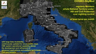
  • 33. 87201590-QCI-TAS-EN/001 COSMO-SkyMed regularly Monitors whole National Territory under ASI and Civil Protection over sighting control at least twice per month with large Data Availability, continuously updated for any possible need, CSK system operational capability allows the development and refinement of advanced applications and analysis techniques Fast and ReliableFast and Reliable