FOSS4G 2011: Mixing It Up with OpenLayers, ArcGIS Server and JavaScript Widgets
2 likes4,677 views

Presented at the Free and Open Source Software for Geospatial (FOSS4G 2011) conference by Allan Glen and David Youngerman.


![# Custom OpenLayers build for Denver Maps[first]OpenLayers/SingleFile.jsOpenLayers.jsOpenLayers/BaseTypes.jsOpenLayers/BaseTypes/Class.jsOpenLayers/Util.jsRico/Corner.js[last][include]# ControlsOpenLayers/Control.jsOpenLayers/Control/PanZoomBar.jsOpenLayers/Control/Navigation.jsOpenLayers/Control/Attribution.jsOpenLayers/Control/Panel.jsOpenLayers/Control/Button.jsOpenLayers/Control/SelectFeature.jsOpenLayers/Control/DragFeature.js# LayersOpenLayers/Layer.jsOpenLayers/Layer/ArcGIS93Rest.jsOpenLayers/Layer/Google.jsOpenLayers/Layer/Google/v3.js# FiltersOpenLayers/Filter.jsOpenLayers/Filter/Comparison.jsOpenLayers/Filter/Spatial.js# RulesOpenLayers/Rule.jsCustom build system – use only what you need](https://image.slidesharecdn.com/allanglendavidyoungerman-mixingitupwithopenlayersarcgisserverandjavascriptwidgets-110923085705-phpapp02/85/FOSS4G-2011-Mixing-It-Up-with-OpenLayers-ArcGIS-Server-and-JavaScript-Widgets-31-320.jpg)


Ad
More Related Content
What's hot (19)
Similar to FOSS4G 2011: Mixing It Up with OpenLayers, ArcGIS Server and JavaScript Widgets (20)


Ad
Recently uploaded (20)


Ad
FOSS4G 2011: Mixing It Up with OpenLayers, ArcGIS Server and JavaScript Widgets
- 1. Mixing It Up with OpenLayers, ArcGIS Server and JavaScript WidgetsAllan Glen, David YoungermanCity and County of Denver
- 2. Let’s say you’re running your GIS on a vendor platform…http://www.sxc.hu/photo/1360623
- 4. ..but you want to mix and match some pieces.open source?http://www.sxc.hu/photo/1056131
- 6. It wasn’t long ago…http://www.sxc.hu/photo/374039
- 7. …that it was really hard to connect to proprietary GIS systems.Based on http://www.sxc.hu/photo/941284
- 8. …but times have changed.(mostly)Based on http://www.sxc.hu/photo/1223568
- 9. Google Trends: REST APISource: http://www.google.com/trends?q=rest+api
- 10. Google Trends: XML vs. JSONhttp://blog.programmableweb.com/2010/12/03/json-continues-its-winning-streak-over-xml/Source: http://www.google.com/trends?q=xml,json
- 11. Google Trends: jQuerySource: http://www.google.com/trends?q=jquery
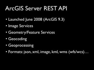
- 12. ArcGIS Server REST API Launched June 2008 (ArcGIS 9.3)
- 13. Image Services
- 15. Geocoding
- 16. Geoprocessing
- 17. Formats: json, xml, image, kml, wms (wfs/wcs)…Our goal:To build maps as embeddable widgets..http://www.sxc.hu/photo/1052928
- 18. ..that could easily be inserted into existing pages.HTMLsnippethttp://www.sxc.hu/photo/1281812
- 19. A Flash widget
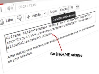
- 20. An IFRAME widget
- 21. A JavaScript widget(the technique we are using)
- 22. What we wanted to avoid…Main Website“GIS Map Viewer”http://www.sxc.hu/photo/1114801
- 23. Mapping Apps as Widgets Maps in context
- 25. Interaction between map and page
- 26. Embed in external websitesESRI ArcGIS ServerJavaScript APIOpenLayersGoogle MapsBing MapsLots of optionsfor JS mapping APIs.. http://www.sxc.hu/photo/1070609
- 31. # Custom OpenLayers build for Denver Maps[first]OpenLayers/SingleFile.jsOpenLayers.jsOpenLayers/BaseTypes.jsOpenLayers/BaseTypes/Class.jsOpenLayers/Util.jsRico/Corner.js[last][include]# ControlsOpenLayers/Control.jsOpenLayers/Control/PanZoomBar.jsOpenLayers/Control/Navigation.jsOpenLayers/Control/Attribution.jsOpenLayers/Control/Panel.jsOpenLayers/Control/Button.jsOpenLayers/Control/SelectFeature.jsOpenLayers/Control/DragFeature.js# LayersOpenLayers/Layer.jsOpenLayers/Layer/ArcGIS93Rest.jsOpenLayers/Layer/Google.jsOpenLayers/Layer/Google/v3.js# FiltersOpenLayers/Filter.jsOpenLayers/Filter/Comparison.jsOpenLayers/Filter/Spatial.js# RulesOpenLayers/Rule.jsCustom build system – use only what you need
- 33. Works well with the ArcGIS Server REST API Dynamic map services
- 34. Cached map services
- 35. REST API
- 36. Raw tiles (but not bundles) Geometry (custom AgsJsAdapter.js) http://trac.osgeo.org/openlayers/ticket/2748Wrench icon from http://ipholio.deviantart.com
- 37. Broad Format Support OGC Web Map Service (WMS)
- 38. XYZ layers
- 40. Bing, Google Maps
- 41. GeoJSON, GeoRSS, KML, WFS, Text
- 43. etc.Avoid vendor lock-inhttp://www.sxc.hu/photo/1339522
- 44. Use your favorite JS libraryetc..
- 46. Launched in 2005
- 47. Last release was 2.11 on 9/11/2011
- 49. Helped add recent support for mobile devices
- 50. In active development
- 52. Embed a fully interactive map in a page with a small snippet of code. Supports address and intersection search,auto-complete, and a Google basemapmashup with points projected on the fly from the ArcGIS Server REST API.<script language="javascript" src="http://www.denvergov.org/maps/api/js/v1?key=479480FE-34A7-4D73-8313-30C8A41AF903"></script><div id="map" style="width: 590px; height: 450px;"></div><script language="javascript">DenverMaps.load("map", { app: “Parks" });</script>
- 53. An example showing a “skinned” Denver Maps application versus the default OpenLayers map. The look and feel of an OpenLayers map is easy to customize using CSS. The graphics from the controls were modified from the theme provided by MapBox at http://support.mapbox.com/kb/mapping-101/openlayers-themes.
- 54. An example showing our parks map overlaying detailed park facilities using an ArcGIS Server Cached Map Service. The tiles have transparency allowing the details to be displayed seamlessly on top of the Google Maps base map. This example uses the XYZ layer type to access tiles through the ArcGIS Server REST API.
- 55. An example showing our traffic conditions map that uses raw ArcGIS Server tiles provided by the Colorado Department of Transportation (CDOT) through www.cotrip.org. This example uses the ArcGISCache layer type which accesses ArcGIS tiles without using the ArcGIS Server REST API.
- 56. An example showing our zoning map that use an ArcGIS Server Dynamic Map Service (export image). This example uses the ArcGIS93Rest layer type. Image transparency can be set on the client using OpenLayers.
- 57. Using JSONP avoids the same-origin policy for cross domain communications, allowing widgets to be embedded on domains other than the domain they are provided from. This example uses a callback (the callback parameter is cut off in the screenshot) to tell ArcGIS Server to return the JSON padded in a callback.
- 58. An example showing how JavaScript map widgets can be used to provide full interactivity with a host page. In this example, the page executes an address search on the map, causing the map to zoom and display a popup.
Editor's Notes
- #3: Let’s say you’re running your GIS on a vendor platform…
- #7: Keep in mind that it wasn’t very long ago
- #8: That interfaces were mostly proprietary and it was hard to mix and match
- #14: To build maps as embeddable widgets..
- #15: ..that can easily be embedded into an existing page.This is very different from the normal approach with an API like Google Maps, the ESRI JavaScript API, or Open Layers where you actually build the mapping application into the page.. With a widget we’re providing the entire mapping app from another location and then allowing the result to be easily embedded into any page. The page doesn’t care about the mapping API we’re using..
- #16: So you’ve seen the widget concept before.. Here is an example from Vimeo that provides snippet to embed a flash object.
- #17: Here is another example from YouTube that uses an IFRAME to embed a video.
- #18: And here is another example from Twitter. This is a JavaScript widget which is the technique that we will be talking about.So why would you want to do this with maps?
- #19: Here is a common use case which is also our use case.
- #21: Choosing a JS Mapping API
- #34: Examples, in case demo doesn’t work.
- #39: Examples, in case demo doesn’t work.
- #40: Examples, in case demo doesn’t work.