Sensors for remote sensing
29 likes22,876 views

This document discusses remote sensing and geographical information systems in civil engineering. It covers various topics related to remote sensing sensors including optical sensors, thermal scanners, multispectral sensors, passive and active sensors, scanning and non-scanning sensors, imaging and non-imaging sensors, and the different types of resolutions including spatial, spectral, radiometric, and temporal resolution. It provides examples and illustrations of these concepts.


Ad
More Related Content
What's hot (20)
Viewers also liked (6)


Ad
Similar to Sensors for remote sensing (20)


Ad
More from Mohsin Siddique (20)
![Engineering Economics: Solved exam problems [ch1-ch4]](https://cdn.slidesharecdn.com/ss_thumbnails/solvedexamproblemsch1-ch4-200220070043-thumbnail.jpg?width=560&fit=bounds)


Recently uploaded (20)


Sensors for remote sensing
- 1. APPLICATION OF REMOTE SENSING AND GEOGRAPHICAL INFORMATION SYSTEM IN CIVIL ENGINEERING Date: INSTRUCTOR DR. MOHSIN SIDDIQUE ASSIST. PROFESSOR DEPARTMENT OF CIVIL ENGINEERING
- 2. Optical Remote Sensing 2 Optical remote sensing makes use of visible, near infrared and short-wave infrared sensors to form images of the earth's surface by detecting the solar radiation reflected from targets on the ground Photography (Photogrammetry) Thermal Scanner Multispectral
- 3. Sensor for Remote Sensing 3
- 4. Wave Length Band for Principal Sensor 4
- 5. We shall concentrate the discussion on optical-mechanical-electronic radiometers and scanners, leaving the subjects of camera-film systems and active radar for Seminar assignment !! Major elements of Electro-optical Scanner Optical System: lenses, mirrors, apertures, modulators and dispersion devices Detectors: provides an electrical signal proportional to the irradiance on its active surface, generally some type of semiconductors Signal processors: perform specified functions on the electrical signal to provide the desired output data Sensor: Optical-Mechanical-Electrical Sensors A typical electro-optical sensor design. 5
- 6. The two broadest classes of sensors are Passive (energy leading to radiation received comes from an external source, e.g., the Sun; the MSS is an example) and Active (energy generated from within the sensor system is beamed outward, and the fraction returned is measured; radar is an example) Sensor for Remote Sensing 6
- 7. Another attribute in this classification is whether the sensor operates in a non-scanning or a scanning mode. If the scene is sensed point by point (equivalent to small areas within the scene) along successive lines over a finite time, this mode of measurement makes up a scanning system. And if the entire scene is sensed directly with the sensor then its terms as non- scanning system Most non-camera sensors operating from moving platforms image the scene by scanning. For example, A film camera held rigidly in the hand is a non-scanning device that captures light almost instantaneously when the shutter is opened, then closed. But when the camera and/or the target moves, as with a movie camera, it in a sense is performing scanning as such. Sensor for Remote Sensing 7
- 8. Sensors can be Non-imaging (measures the radiation received from all points in the sensed target, integrates this, and reports the result as an electrical signal strength or some other quantitative attribute, such as radiance) or Imaging (the electrons released are used to excite or ionize a substance like silver (Ag) in film or to drive an image producing device like a TV or computer monitor or a cathode ray tube or oscilloscope or a battery of electronic detectors Sensor for Remote Sensing 8
- 9. Radiometer is a general term for any instrument that quantitatively measures the EM radiation in some interval of the EM spectrum. When the radiation is light from the narrow spectral band including the visible, the term photometer can be substituted. If the sensor includes a component, such as a prism or diffraction grating, that can break radiation extending over a part of the spectrum into discrete wavelengths and disperse (or separate) them at different angles to an array of detectors, it is called a spectrometer. Sensor for Remote Sensing 9
- 10. The term spectro-radiometer is reserved for sensors that collect the dispersed radiation in bands rather than discrete wavelengths. Most air/space sensors are spectroradiometers. Sensors that instantaneously measure radiation coming from the entire scene at once are called framing systems. The eye, a photo camera, and a TV vidicon belong to this group. Sensor for Remote Sensing 10
- 11. The optical setup for imaging sensors will be either an image plane or an object plane set up depending on where lens is before the photon rays are converged (focused), as shown in the illustration. Sensor for Remote Sensing For the image plane arrangement, the lens receives parallel light rays after these are deflected to it by the scanner, with focusing at the end. For the object plane setup, the rays are focused at the front end (and have a virtual focal point in back of the initial optical train), and are intercepted by the scanner before coming to a full focus at a detector. 11
- 12. Two broad categories of most scanners are defined by the terms "optical-mechanical" and "optical-electronic", Both are distinguished by the former containing an essential mechanical component (e.g., a moving mirror) that participates in scanning the scene and by the latter having the sensed radiation move directly through the optics onto a linear or two-dimensional array of detectors Sensor for Remote Sensing optical-mechanical optical- electronic 12
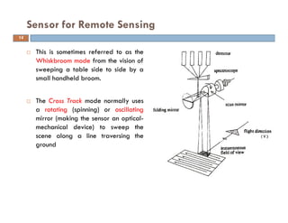
- 13. Another attribute of remote sensors, not shown in the classification, relates to the modes in which those that follow some forward-moving track (referred to as the orbit or flight path) gather their data. Cross-track scanners Along track scanners Sensor for Remote Sensing In doing so, they are said to monitor the path over an area out to the sides of the path; this is known as the swath width. 13
- 14. This is sometimes referred to as the Whiskbroom mode from the vision of sweeping a table side to side by a small handheld broom. The Cross Track mode normally uses a rotating (spinning) or oscillating mirror (making the sensor an optical- mechanical device) to sweep the scene along a line traversing the ground Sensor for Remote Sensing 14
- 15. Also known as Pushbroom Scanners Sense a swath with an linear array of CCD’s Because pushbroom scanners have no mechanical parts, their mechanical reliability can be very high Sensor for Remote Sensing 15
- 16. Spatial Resolution Spectral Resolution Radiometric Resolution Temporal Resolution Sensor Resolutions The ratio of distance on an image or map, to actual ground distance is referred to as scale. 16 radiometric
- 17. Instantaneous Field of View (IFOV) is the angular cone of visibility of the sensor (A) and determines the area on the Earth's surface which is "seen" from a given altitude at one particular moment in time (B) Spatial Resolution 17
- 18. This is a measure of the area or size of the smallest dimensions on the earth’s surface over which an independent measurement can be made by the sensor It is expressed by the size of the pixel on the ground in m A measure of size of pixel is given by the IFOV, which is dependent on the altitude and the viewing angle of the sensor A narrow viewing angle or a lower altitude produces a small IFOV If a sensor has a spatial resolution of 20 metres and an image from that sensor is displayed at full resolution, each pixel represents an area of 20m x 20m on the ground For a pushbroom system the number of detectors influences the spatial resolution A system with 1,000 detectors that images a 50 km wide swath has a pixel size of 50m Spatial Resolution 18
- 20. http://webhelp.esri.com/arcgiSDEsktop/9.3/index.cfm?TopicName=Cell_size _of_raster_data Spatial Resolution In this case, resolution refers to the pixel (cell) size (the area covered on the ground and represented by a single cell). A higher spatial resolution implies that there are more pixels per unit area; therefore, the graphic on the left represents a higher spatial resolution than the graphic on the right. 20
- 22. Spatial Resolution versus Scale The spatial resolution of the data used in the image on the left is lower than the spatial resolution of the data used in the image on the right. This means the cell size of the data in the left image is larger than that of the data in the right image; however, the scale at which each is displayed is the same. The scale of the image on the left (1:50,000) is smaller than the scale of the image on the right (1:2,500); however, the spatial resolution (cell size) of the data is the same. 22
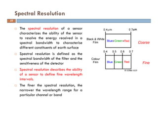
- 23. The spectral resolution of a sensor characterizes the ability of the sensor to resolve the energy received in a spectral bandwidth to characterise different constituents of earth surface Spectral resolution is defined as the spectral bandwidth of the filter and the sensitiveness of the detector Spectral resolution describes the ability of a sensor to define fine wavelength intervals. The finer the spectral resolution, the narrower the wavelength range for a particular channel or band Spectral Resolution Coarse Fine 23
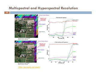
- 24. Many remote sensing systems record energy over several separate wavelength ranges at various spectral resolutions. These are referred to as multi-spectral, superspectral, and hyperspectral sensors Spectral Resolution Panchromatic Multispectral 24
- 25. Multispectral and Hyperspectral Resolution http://auracle.ca/news/ 25
- 26. The radiometric resolution of an imaging system describes its ability to discriminate very slight differences in energy. i.e., it is a measure of how many grey levels are measured between pure black (no reflectance) to pure white. It is measured in bits Radiometric Resolution Examples 1 bit (21) – 2 levels 7 bits (27) – 128 levels IRS 1A & 1B 8 bits (28) – 256 levels Ladnsat TM 11 bits (211) – 2048 levels NOAA – AVHRR In a 8 bit system, black is measured as 0 and white is measured as 255. Imagery data are represented by positive Digital Numbers (DN) which vary from 0 to (one less than) a selected power of 2 according to bit system. 26
- 27. Radiometric Resolution 0 1 27 1 bit (21) 8 bits (28) 8 bits (28)
- 28. A remote sensing system with a radiometric resolution of 6 bits assigns a digital number (DN) of 28 to one surface and 47 to another. What would be the equivalent DNs for the same surfaces if the measurements were taken with a 3 bit system? The DNs recorded by the 3 bit system range from 0 to 7 and this range is equivalent to 0-64 for the 6 bit system 0 1 2 3 4 5 6 7 (3 bit) 0 9 18 27 36 45 54 63 (6 bit) Therefore a DN of 28 and 47 on the 6 bit system will be recorded as 3 and 5 on a 3 bit system. Radiometric Resolution 28
- 29. Temporal resolution of a remote sensing system is a measure of how often data are obtained for the same area Applicable to satellite remote sensing only Temporal resolution varies from less than one hour to approximately 30 days. Importance of Temporal Resolution Change in Land Use/ Land Cover Temporal Variation Monitoring of a Dynamic Event Cyclone Flood Volcano Earthquake Temporal Resolution 29
- 30. Comments…. Questions…. Suggestions…. 30 I am greatly thankful to all the information sources (regarding remote sensing and GIS) on internet that I accessed and utilized for the preparation of present lecture. Thank you ! Feel free to contact