Web Based GIS LeadGen Introduction
Download as ppsx, pdf3 likes456 views

This document provides an overview of the key features and functionality of a web-based geographic information system (GIS). It describes the main components including databases, mapping capabilities, and interactive tools. The system allows users to search for and view property data, print maps, and export/import data in common formats. Detailed information and help documents are accessible through an online help button.


Web Based GIS LeadGen Introduction
- 1. What is a Geographic Information System (GIS)?DatabaseMappingInteractiveGIS Web-based GIS TechnologyDatabase + Map = GISSmart Map
- 2. Key features – Output: Print engineer-grade, scaled maps in a wide variety of sizes.The Print Manager provides the ability to select, view, manage, and print maps ranging in size from 8.5" by 11" (ANSI A) to 34" by 44" (ANSI E). All of which are plotted to scale. Predefined Templates
- 3. Markup Tools (not available on this version)
- 6. Print Output ModeEver try to fit an entire water distribution system on an 8.5 by 11 inch piece of paper?
- 7. Key features – Customizability: no matter your web-based GIS needs, we’ve designed a solutionA Map of the Area of InterestYour Electronic Filing Cabinet Enhanced Rollover – Coming Soon!CCTV Video Inspection
- 8. Key features – Significant Savings: saving thousands of your valuable dollars per project.What is Open Source Software?
- 9. The term open source refers to any freely-distributed software whose source code is intentionally made available for people to examine and modify.
- 10. InteractiveGIS is Built on the Open Source Software MapServer®
- 11. Developed by NASA & University of Minnesota
- 12. No GIS Experience Necessary
- 13. Point and Click Functionality
- 14. Most people already know how to work an Internet browser
- 15. Immediate Savings on ALL Software Costs
- 16. Your Budget is Focused on Developing the Required Tools
- 17. When you take out the maintenance and the licensing of server software, you can focus your money directly on the problem and solution Key features – Online Hosting: we do the work to keep your data online, backed up, and secure.No Server Maintenance
- 19. No Commercial Software to PurchaseKey features – Better Tools: the nearly endless possibilities.Any number of query combinations
- 20. Maps you can draw on digitally
- 21. More levels of connection between your items of data
- 22. And much more!Markup Tools Include: Add Symbols
- 23. Add Lines
- 24. Add Text
- 25. Definable Line Weights, Colors, and Text/Symbol Size
- 26. Clear Markup by Step or Clear All
- 27. PrintableKey features – Security: a tiered security system.Guest User :Limits public access to certain informationAllows you to give their info-seekers access to only the information they need.Registered User :Provides additional information
- 28. Key features – Data Format: exporting/importing data in a range formats such as SHP, DXF, PDF, CSV allowing you to update your systems with ease.Exchange Data Between Software Platforms
- 29. Share Information with Consultants and other departmentsThe InterfaceTabsSide PanelTool Bar - Navigation & Common ToolsIcons - Just the Facts, Print Manager, and HelpMap AreaDashboard413526
- 30. The Tool BarZoom In - zooms-in by either clicking on the map or by drawing a box around the region of interest. Zoom Out - zooms-out by either clicking on a point on the map near the region of interest. Zoom Extents- Displays the full geographic extent of all visible layers. Pan - Click on the map and drag the cursor with the left mouse button down. This will move the view extent in any direction. Identify - Click on a feature within the map to display attribute information. The information is shown on the Results tab. Measure - This tool is used to measure distance and/or area on the map. This information is displayed at the bottom of the interface. Rectangle/Point Feature Selection - This tool is used to make a rectangular or circular selection of features found on the map. Polygon Feature Selection - This tool is used to make a selection within the polygon of features found on the map.
- 31. Map View TabMap View TabQuick ZoomZoom to a CommunityZoom to a Public BuildingQuick SearchEnables the user to search by any one or all of the following:ParcelAccount NumberOwner (if registered user)Street NumberE-911 AddressSelection Tools (used in conjunction with tool bar rectangle and polygon selection tools)Identify which layer to searchSpecify the search buffer distanceMarkupButtonsResetCancelClear
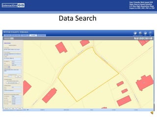
- 32. Data SearchInteractiveGIS is the link between data and real-world featuresThe Digital Filing CabinetEasy as 1-2-3…4!2341
- 33. Data Search
- 34. Data Search
- 35. Data Search
- 36. Just the FactsJust the Facts (JTF) is a very powerful tool by itself to look at a specific feature. It not only gives the user detailed information about feature but it also gives additional spatial information about the surrounding area.Print - Sends the results to the printer.Email - Opens up Microsoft Office's Outlook and generates the appropriate link.
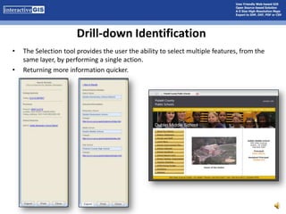
- 37. Drill-down IdentificationThe Selection tool provides the user the ability to select multiple features, from the same layer, by performing a single action. Returning more information quicker.
- 38. Map Layers TabTo control the visibility of a map layer, complete the following steps: Select the Map Layers tabLocate the layer of interestClick the checkbox to toggle the visibility of that layerClick the Update button located at the bottom of the side panel. The system will regenerate a new map with only the selected layers visible.
- 39. Search TabProperty SearchEnables the user to search by any one or all of the following:ParcelAccount NumberOwner (if registered user)Street NumberE-911 AddressDeed Book & Page Search
- 40. Enter a deed book and page number and hit Search.
- 41. Range Searches
- 42. Enter a range for the Acreage and press Search.
- 43. Enter a Map Number or rangeThe results are displayed on the Results tab.
- 44. Results Tab - Initial ReturnsInitial Results - Regardless of how the search was initiated, the Results Tab will provide a list of features that either matched the selection criteria or were returned as the result of one of the selection tools. Note that at the top of the Result Tab the system provides a critical piece of information about how the system understood what the user was searching:Search Query: Owner equals smith Note - the above statement describes how the system understood your query. If this is incorrect please adjust your query and retry.The initial results provide links to additional information
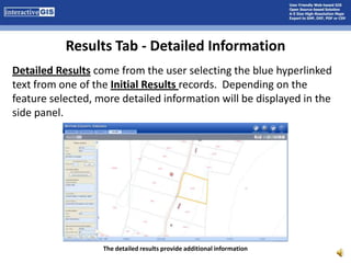
- 45. Results Tab - Detailed InformationDetailed Results come from the user selecting the blue hyperlinked text from one of the Initial Results records. Depending on the feature selected, more detailed information will be displayed in the side panel.The detailed results provide additional information
- 46. Results Tab - Adjoiners To find out information about surrounding properties use the Get Adjoining Parcels tool.Adjoining parcels are highlightedTo find out even MORE information about surrounding properties continue to use the Get Adjoining Parcels tool.
- 47. Adjust the Buffer Distance to cross over streets to get parcels on the other side of the road if necessary.Results Tab – Print & ExportPrint & Export FunctionalityExport – CSV formatPrint – Directly to PDF
- 48. Detailed Online Help & Training The Help button is located at the top right of the interface.Easily Updated since it is on the server – no costly updates to distribute “Users Manuals” and covers all topics in one place.General Side Panel Toolbar Preference & Settings Map View Tab Map Layer Tab Search Tab Results Tab Just the Facts Print Manager The Help Button