A Practical Introduction to GeoJSON
1 like191 views

This document introduces GeoJSON, a format for representing geospatial data in JSON. It describes the common GeoJSON data types like points, lines, and polygons that represent locations, routes, and areas on a map. It provides examples of how GeoJSON can be used for applications like geocoding, routing directions, geofencing, and geospatial queries in databases. The presenter works on optimizing fuel delivery routes using GeoJSON to represent customer locations, vehicle capacity, and projected demand.


![Point Data Structure
● Type and coords
● [lng, lat]
● Longitude first](https://image.slidesharecdn.com/apracticalintroductiontogeojson-200301234122/85/A-Practical-Introduction-to-GeoJSON-7-320.jpg)


Ad
More Related Content
Similar to A Practical Introduction to GeoJSON (20)
More from Valeri Karpov (20)


Ad
Recently uploaded (20)


Ad
A Practical Introduction to GeoJSON
- 1. A Practical Introduction to GeoJSON Valeri Karpov @code_barbarian github.com/vkarpov15
- 2. What’s This Talk About? ● GeoJSON, or, fun with maps ● What you need to know for building apps ● Using the Mapbox API ● Visualizations using geojson.us
- 3. About Me ● Building Node.js apps since 2012 ● Lead developer on Mongoose, Node.js+MongoDB ODM ● Blogger, thecodebarbarian.com & masteringjs.io ● Early employee at: ○ LevelUp - Bought by Grubhub for $380M in 2018 ○ MongoDB - IPO in 2017 ○ Booster Fuels - $88M in funding since 2015
- 4. Geospatial Data: What is It? ● Points and shapes on a map (latitude and longitude)
- 5. Brief Overview of JSON ● Pronounced “jay-son”: JavaScript Object Notation ● Object = string properties (keys), arbitrary values ● Human readable format ● Almost a subset of JavaScript
- 6. GeoJSON Data Types ● Points: where did an Uber customer request pickup? ● Lines: how do you drive from point A to point B? ● Polygons: what are the borders of Colorado?
- 7. Point Data Structure ● Type and coords ● [lng, lat] ● Longitude first
- 8. Geocoding: A Use Case for Points ● Convert text “429 lenox ave miami” ⇒ GeoJSON point ● Usually via API, like Google Maps or Mapbox
- 9. Line Data Structure ● Type and coords ● Coords is array of arrays ● Longitude first
- 10. Lines for Driving Directions ● How to drive from WeWork to MIA Airport?
- 11. Polygon Data Structure ● Type and coords ● Coords is a triple nested array
- 12. Multi Polygons ● Polygon coords are triple nested because you can have multiple polygons in 1!
- 13. Polygons and Geofencing ● Polygons help apps be relevant for locations ● Push notifications, special pricing ● How does Uber know you’re in an airport?
- 14. Checking if a Point is in a Polygon ● Common polygon use case: check if user is in a polygon
- 15. Using Turf.js ● Turf.js provides numerous geospatial helpers
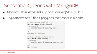
- 16. Geospatial Queries with MongoDB ● MongoDB has excellent support for GeoJSON built in ● `$geoIntersects` finds polygons that contain a point
- 17. My Current Work ● Booster does gas delivery ● Trucks with certain fueling capacity ● Customers with projected demand ● What’s the most efficient route?
- 18. Routing System Components ● Routing between 2 customers: how long does it take to get from Santa Monica to Dana Point? ● Customers are represented by GeoJSON polygons, so our driver app provides location-aware information ● Vehicle Routing Problem solver that optimizes routes ● Forecasting demand based on historical data
- 19. Moving On ● GeoJSON is a huge part of modern apps ● Points, LineStrings, Polygons get you most of the way ● Points represent individual locations ● Lines represent routes ● Polygons represent areas (states, airports, etc.)
- 20. Further Reading ● GeoJSON intro on my blog: bit.ly/geojson-node ● MongoDB geo queries: bit.ly/mongodb-geo ● Mongoose GeoJSON docs: bit.ly/mongoose-geo